

547. Befreiungshalle Kelheim, Altmühlmündung und Burgruine Randeck
A cycling route starting in Essing, Bavaria, Germany.
Overview
About this route
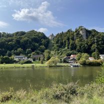
- ridden on Thursday (FT), 26.05.22 in nine (varied finishes) as part 3 of the MTT Essing - 14...19°C, moderate W wind, partly sunny, partly heavily overcast - impressive: Befreiungshalle Kelheim - interesting: wooden bridge 'Tatzelwurm' in Essing / small ferry Dolnau Eining - Hienheim / karst spring Blautopf in Essing - before Befreiungshalle hit the 70 (70.2 km/h) - beautiful view from the tower of the Randeck castle ruins over Essing
- -:--
- Duration
- 81.8 km
- Distance
- 1,182 m
- Ascent
- 1,183 m
- Descent
- ---
- Avg. speed
- 534 m
- Max. altitude
Route quality
Waytypes & surfaces along the route
Waytypes
Quiet road
30.3 km
(37 %)
Road
22.9 km
(28 %)
Surfaces
Paved
65.4 km
(80 %)
Unpaved
2.5 km
(3 %)
Asphalt
63.8 km
(78 %)
Paved (undefined)
1.6 km
(2 %)
Continue with Bikemap
Use, edit, or download this cycling route
You would like to ride 547. Befreiungshalle Kelheim, Altmühlmündung und Burgruine Randeck or customize it for your own trip? Here is what you can do with this Bikemap route:
Free features
- Save this route as favorite or in collections
- Copy & plan your own version of this route
- Split it into stages to create a multi-day tour
- Sync your route with Garmin or Wahoo
Premium features
Free trial for 3 days, or one-time payment. More about Bikemap Premium.
- Navigate this route on iOS & Android
- Export a GPX / KML file of this route
- Create your custom printout (try it for free)
- Download this route for offline navigation
Discover more Premium features.
Get Bikemap PremiumFrom our community
Other popular routes starting in Essing
 Von Altessing nach Regensburg
- Distance
- 43.1 km
- Ascent
- 176 m
- Descent
- 185 m
- Location
- Essing, Bavaria, Germany
 Riedenburg Faßl Ausflug
- Distance
- 18.7 km
- Ascent
- 138 m
- Descent
- 136 m
- Location
- Essing, Bavaria, Germany
 D_Bayern_Essing-Schulerloch-Obernederhweg-Schlaufe-26)_RR-23km-530hm
- Distance
- 23 km
- Ascent
- 649 m
- Descent
- 649 m
- Location
- Essing, Bavaria, Germany
 Vom Schulerloch nach Dietfurt
- Distance
- 29.3 km
- Ascent
- 76 m
- Descent
- 64 m
- Location
- Essing, Bavaria, Germany
 D10 Weltenburg - Wörth
- Distance
- 79.8 km
- Ascent
- 360 m
- Descent
- 376 m
- Location
- Essing, Bavaria, Germany
 Von Kelheim bis Straubing
- Distance
- 94.9 km
- Ascent
- 413 m
- Descent
- 444 m
- Location
- Essing, Bavaria, Germany
 Essing Altmühltal RF
- Distance
- 31.1 km
- Ascent
- 180 m
- Descent
- 183 m
- Location
- Essing, Bavaria, Germany
 48.926, 11.802 a 49.106, 11.444
- Distance
- 55.5 km
- Ascent
- 285 m
- Descent
- 252 m
- Location
- Essing, Bavaria, Germany
Open it in the app