

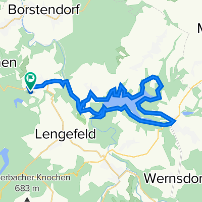
Saidenbachtalsperre 2022-04-12
A cycling route starting in Börnichen, Saxony, Germany.
Overview
About this route
null
- -:--
- Duration
- 25.2 km
- Distance
- 510 m
- Ascent
- 510 m
- Descent
- ---
- Avg. speed
- 504 m
- Max. altitude

Route quality
Waytypes & surfaces along the route
Waytypes
Track
13.6 km
(54 %)
Road
7.1 km
(28 %)
Surfaces
Paved
12.1 km
(48 %)
Unpaved
11.6 km
(46 %)
Asphalt
12.1 km
(48 %)
Unpaved (undefined)
6.8 km
(27 %)
Continue with Bikemap
Use, edit, or download this cycling route
You would like to ride Saidenbachtalsperre 2022-04-12 or customize it for your own trip? Here is what you can do with this Bikemap route:
Free features
- Save this route as favorite or in collections
- Copy & plan your own version of this route
- Sync your route with Garmin or Wahoo
Premium features
Free trial for 3 days, or one-time payment. More about Bikemap Premium.
- Navigate this route on iOS & Android
- Export a GPX / KML file of this route
- Create your custom printout (try it for free)
- Download this route for offline navigation
Discover more Premium features.
Get Bikemap PremiumFrom our community
Other popular routes starting in Börnichen
 Höllenritt
- Distance
- 7.1 km
- Ascent
- 213 m
- Descent
- 213 m
- Location
- Börnichen, Saxony, Germany
 Saidenbachtalsperre 2022-04-12
- Distance
- 25.2 km
- Ascent
- 510 m
- Descent
- 510 m
- Location
- Börnichen, Saxony, Germany
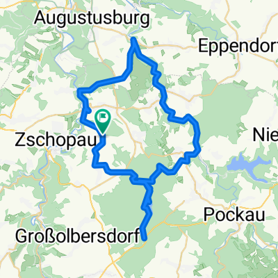
 Bornwald
- Distance
- 22 km
- Ascent
- 340 m
- Descent
- 329 m
- Location
- Börnichen, Saxony, Germany
 Fahrradtour Stevens - Fahrradtour Stevens
- Distance
- 9.8 km
- Ascent
- 248 m
- Descent
- 248 m
- Location
- Börnichen, Saxony, Germany
 Trip 2022-08-11
- Distance
- 51.8 km
- Ascent
- 1,205 m
- Descent
- 1,205 m
- Location
- Börnichen, Saxony, Germany
 Waldkirchener Straße 38, Zschopau nach Waldkirchener Straße 38, Zschopau
- Distance
- 41.7 km
- Ascent
- 801 m
- Descent
- 820 m
- Location
- Börnichen, Saxony, Germany
 Garten-Heim-Alternativ
- Distance
- 22.7 km
- Ascent
- 513 m
- Descent
- 618 m
- Location
- Börnichen, Saxony, Germany
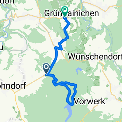 Die neue Kalkstraße, Zschopau nach Am Sportplatz 1, Grünhainichen
- Distance
- 14 km
- Ascent
- 206 m
- Descent
- 316 m
- Location
- Börnichen, Saxony, Germany
Open it in the app