

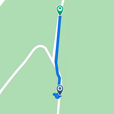
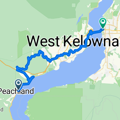
49.724° N -119.525° W to 49.691° N -119.536° W
A cycling route starting in Peachland, British Columbia, Canada.
Overview
About this route
- 29 min
- Duration
- 4 km
- Distance
- 37 m
- Ascent
- 53 m
- Descent
- 8.3 km/h
- Avg. speed
- 1,214 m
- Max. altitude

Route quality
Waytypes & surfaces along the route
Waytypes
Quiet road
4 km
(100 %)
Surfaces
Unpaved
4 km
(100 %)
Unpaved (undefined)
4 km
(100 %)
Continue with Bikemap
Use, edit, or download this cycling route
You would like to ride 49.724° N -119.525° W to 49.691° N -119.536° W or customize it for your own trip? Here is what you can do with this Bikemap route:
Free features
- Save this route as favorite or in collections
- Copy & plan your own version of this route
- Sync your route with Garmin or Wahoo
Premium features
Free trial for 3 days, or one-time payment. More about Bikemap Premium.
- Navigate this route on iOS & Android
- Export a GPX / KML file of this route
- Create your custom printout (try it for free)
- Download this route for offline navigation
Discover more Premium features.
Get Bikemap PremiumFrom our community
Other popular routes starting in Peachland
 49.724° N -119.525° W to 49.691° N -119.536° W
- Distance
- 4 km
- Ascent
- 37 m
- Descent
- 53 m
- Location
- Peachland, British Columbia, Canada
 5920 Highway 97, Peachland to 6756–6778 Thorne Rd, Peachland
- Distance
- 5.3 km
- Ascent
- 151 m
- Descent
- 116 m
- Location
- Peachland, British Columbia, Canada
 KVR - Summerland
- Distance
- 26.4 km
- Ascent
- 238 m
- Descent
- 601 m
- Location
- Peachland, British Columbia, Canada
 V0H 1X3, Peachland to 4 Street 4421, Peachland
- Distance
- 12.4 km
- Ascent
- 79 m
- Descent
- 355 m
- Location
- Peachland, British Columbia, Canada
 4445 Fourth St, Peachland to 13009 Rosedale Ave, Summerland
- Distance
- 22.7 km
- Ascent
- 380 m
- Descent
- 245 m
- Location
- Peachland, British Columbia, Canada
 6769 Thorne Rd, Peachland to 6704–6748 Thorne Rd, Central Okanagan
- Distance
- 0.3 km
- Ascent
- 6 m
- Descent
- 0 m
- Location
- Peachland, British Columbia, Canada
 Route to Kelowna
- Distance
- 43.6 km
- Ascent
- 1,003 m
- Descent
- 1,002 m
- Location
- Peachland, British Columbia, Canada
 4401–4439 Third St, Peachland to 13203 Henry Ave, Summerland
- Distance
- 22.3 km
- Ascent
- 370 m
- Descent
- 237 m
- Location
- Peachland, British Columbia, Canada
Open it in the app