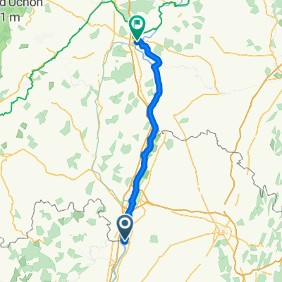
Recovered Route
A cycling route starting in Thoissey, Auvergne-Rh么ne-Alpes, France.
Overview
About this route
- 2 h 49 min
- Duration
- 36.1 km
- Distance
- 228 m
- Ascent
- 54 m
- Descent
- 12.8 km/h
- Avg. speed
- 350 m
- Max. altitude
Route quality
Waytypes & surfaces along the route
Waytypes
Path
7.9 km
(22 %)
Road
7.9 km
(22 %)
Surfaces
Paved
12.8 km
(35 %)
Unpaved
13.1 km
(36 %)
Asphalt
12.8 km
(35 %)
Gravel
12.6 km
(35 %)
Continue with Bikemap
Use, edit, or download this cycling route
You would like to ride Recovered Route or customize it for your own trip? Here is what you can do with this Bikemap route:
Free features
- Save this route as favorite or in collections
- Copy & plan your own version of this route
- Sync your route with Garmin or Wahoo
Premium features
Free trial for 3 days, or one-time payment. More about Bikemap Premium.
- Navigate this route on iOS & Android
- Export a GPX / KML file of this route
- Create your custom printout (try it for free)
- Download this route for offline navigation
Discover more Premium features.
Get Bikemap PremiumFrom our community
Other popular routes starting in Thoissey
- De Chemin de la Place des Fr猫res, Saint-Didier-sur-Chalaronne 脿 Rue de la Villeneuve 634, Crottet
- Distance
- 17.8 km
- Ascent
- 45 m
- Descent
- 40 m
- Location
- Thoissey, Auvergne-Rh么ne-Alpes, France
- De Chemin de Halage 脿 Rue des Canes
- Distance
- 54.9 km
- Ascent
- 137 m
- Descent
- 177 m
- Location
- Thoissey, Auvergne-Rh么ne-Alpes, France
- Esplanade Robert Jolivet, Saint-Symphorien-d'Ancelles nach 10bis Place de l'H么tel de Ville, Chauffailles
- Distance
- 50 km
- Ascent
- 680 m
- Descent
- 443 m
- Location
- Thoissey, Auvergne-Rh么ne-Alpes, France
- Mont Brouilly
- Distance
- 50.5 km
- Ascent
- 509 m
- Descent
- 512 m
- Location
- Thoissey, Auvergne-Rh么ne-Alpes, France
- Vers Sa么ne, Thoissey to Chemin de la Passerelle, Tr茅voux
- Distance
- 32.7 km
- Ascent
- 54 m
- Descent
- 51 m
- Location
- Thoissey, Auvergne-Rh么ne-Alpes, France
- Etape 3 Thoissy Tournus
- Distance
- 51.1 km
- Ascent
- 92 m
- Descent
- 85 m
- Location
- Thoissey, Auvergne-Rh么ne-Alpes, France
- 脡tape 37 De Chemin de Halage 脿 Rue des Canes
- Distance
- 54.8 km
- Ascent
- 127 m
- Descent
- 112 m
- Location
- Thoissey, Auvergne-Rh么ne-Alpes, France
- kpg thoissey - kpg tournus tandem 2017
- Distance
- 52.6 km
- Ascent
- 37 m
- Descent
- 39 m
- Location
- Thoissey, Auvergne-Rh么ne-Alpes, France
Open it in the app