

Schernsdorf - Schlaubetal
A cycling route starting in Mixdorf, Brandenburg, Germany.
Overview
About this route
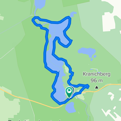
Schernsdorf - Fünfeichen - Kieselwitz - Chossewitz - Dammendorf - Siehdichum - Kupferhammer - Schernsdorf Beautiful cycling routes - hilly
- -:--
- Duration
- 34.5 km
- Distance
- 362 m
- Ascent
- 362 m
- Descent
- ---
- Avg. speed
- 143 m
- Max. altitude
Route quality
Waytypes & surfaces along the route
Waytypes
Path
15.5 km
(45 %)
Quiet road
13.8 km
(40 %)
Surfaces
Paved
32.4 km
(94 %)
Asphalt
31.4 km
(91 %)
Paved (undefined)
1 km
(3 %)
Undefined
2.1 km
(6 %)
Continue with Bikemap
Use, edit, or download this cycling route
You would like to ride Schernsdorf - Schlaubetal or customize it for your own trip? Here is what you can do with this Bikemap route:
Free features
- Save this route as favorite or in collections
- Copy & plan your own version of this route
- Sync your route with Garmin or Wahoo
Premium features
Free trial for 3 days, or one-time payment. More about Bikemap Premium.
- Navigate this route on iOS & Android
- Export a GPX / KML file of this route
- Create your custom printout (try it for free)
- Download this route for offline navigation
Discover more Premium features.
Get Bikemap PremiumFrom our community
Other popular routes starting in Mixdorf
 Raftour 2016
- Distance
- 68.8 km
- Ascent
- 202 m
- Descent
- 206 m
- Location
- Mixdorf, Brandenburg, Germany
 2009 Bremsdorfer Mühle--Cottbus
- Distance
- 68.1 km
- Ascent
- 171 m
- Descent
- 159 m
- Location
- Mixdorf, Brandenburg, Germany
 Bremsdorfm.-Kieselwitz-Wirchensee-Dammendorf-Br
- Distance
- 28.2 km
- Ascent
- 227 m
- Descent
- 226 m
- Location
- Mixdorf, Brandenburg, Germany
 Runde um den Jacobsee
- Distance
- 33.2 km
- Ascent
- 181 m
- Descent
- 179 m
- Location
- Mixdorf, Brandenburg, Germany
 Radtour 2016 LIGHT
- Distance
- 64.4 km
- Ascent
- 227 m
- Descent
- 228 m
- Location
- Mixdorf, Brandenburg, Germany
 Bremsdorfer Mühle 5, Schlaubetal nach Bremsdorfer Mühle 5, Schlaubetal
- Distance
- 12 km
- Ascent
- 95 m
- Descent
- 88 m
- Location
- Mixdorf, Brandenburg, Germany
 Schernsdorf – Reitwein
- Distance
- 51.3 km
- Ascent
- 203 m
- Descent
- 279 m
- Location
- Mixdorf, Brandenburg, Germany
 17.03.2012 Schlaubetal Xtreme
- Distance
- 38.3 km
- Ascent
- 201 m
- Descent
- 200 m
- Location
- Mixdorf, Brandenburg, Germany
Open it in the app