

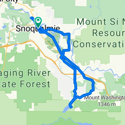
Snoqualmie Falls to Pass
A cycling route starting in Snoqualmie, Washington, United States.
Overview
About this route
Riding from the falls up to the pass, around 600m/2000ft of climbing, mostly along gravel trails. This follows the Snoqualmie Valley Trail, and then Palouse to Cascades state park through Iron Horse.
This route passes through the Snoqualmie pass tunnel, which is only open May-Oct or so, so bring a light for your bike.
Conventional water and food sources are scarce on this ride, between Rattlesnake lake, and the pass itself, there are only streams and the occasional blackberries during the right months.
The start of this ride features pavement, but the rest of the ride is firm gravel. Mountain bikes are not required for this route, but make sure your bike can handle gravel and the occasional muddy puddle well.
The elevation graph shows this route going over the mountain, the tunnel is flat and this ride does not go over the 850m or so in elevation. This mapping tool cannot handle tunnels well.
- -:--
- Duration
- 106.5 km
- Distance
- 3,005 m
- Ascent
- 3,011 m
- Descent
- ---
- Avg. speed
- 1,229 m
- Max. altitude

Route quality
Waytypes & surfaces along the route
Waytypes
Cycleway
96.9 km
(91 %)
Road
5.3 km
(5 %)
Surfaces
Paved
1.1 km
(1 %)
Unpaved
96.9 km
(91 %)
Gravel
96.9 km
(91 %)
Asphalt
1.1 km
(1 %)
Undefined
8.5 km
(8 %)
Continue with Bikemap
Use, edit, or download this cycling route
You would like to ride Snoqualmie Falls to Pass or customize it for your own trip? Here is what you can do with this Bikemap route:
Free features
- Save this route as favorite or in collections
- Copy & plan your own version of this route
- Split it into stages to create a multi-day tour
- Sync your route with Garmin or Wahoo
Premium features
Free trial for 3 days, or one-time payment. More about Bikemap Premium.
- Navigate this route on iOS & Android
- Export a GPX / KML file of this route
- Create your custom printout (try it for free)
- Download this route for offline navigation
Discover more Premium features.
Get Bikemap PremiumFrom our community
Other popular routes starting in Snoqualmie
 Snoqualmie to North Bend
- Distance
- 11.3 km
- Ascent
- 93 m
- Descent
- 53 m
- Location
- Snoqualmie, Washington, United States
 34612 SE Leitz St, Snoqualmie to 10811 SE Lake Rd, Bellevue
- Distance
- 32.3 km
- Ascent
- 197 m
- Descent
- 484 m
- Location
- Snoqualmie, Washington, United States
 Snoqualmie to Rattlesnake Lake
- Distance
- 17.5 km
- Ascent
- 251 m
- Descent
- 93 m
- Location
- Snoqualmie, Washington, United States
 Snoqualmie bridge to rattlesnake out-and-back
- Distance
- 31.6 km
- Ascent
- 273 m
- Descent
- 269 m
- Location
- Snoqualmie, Washington, United States
 Blistering ride in Fall City
- Distance
- 30.1 km
- Ascent
- 159 m
- Descent
- 273 m
- Location
- Snoqualmie, Washington, United States
 Tokul Road Southeast, Snoqualmie to Main Street Northeast 15630, Duvall
- Distance
- 30.5 km
- Ascent
- 82 m
- Descent
- 137 m
- Location
- Snoqualmie, Washington, United States
 Railroad Avenue 7880, Snoqualmie to Railroad Avenue 7850, Snoqualmie
- Distance
- 39.6 km
- Ascent
- 308 m
- Descent
- 303 m
- Location
- Snoqualmie, Washington, United States
 Snoqualmie to Rattlesnake Lake
- Distance
- 19.7 km
- Ascent
- 236 m
- Descent
- 186 m
- Location
- Snoqualmie, Washington, United States
Open it in the app