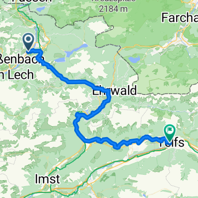
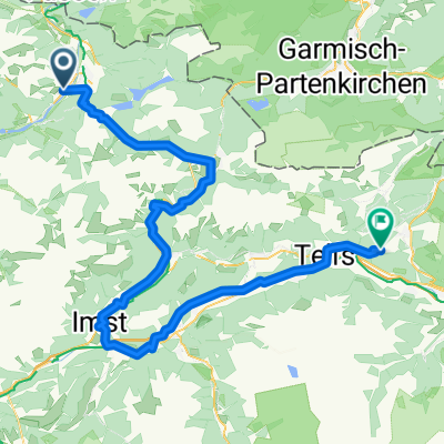
ET4 MötzingenBurgeis: (Weissenbach) -Imst - Landeck Nauders- Burguiso
A cycling route starting in Höfen, Tyrol, Austria.
Overview
About this route
<span style="font-family: Arial; font-size: 15px; white-space: pre-wrap; color: #000000;">ET4 MötzingenBurgeis: (Weissenbach) -Imst - Landeck  Nauders- Burguiso</span>
Etappe 4: Mötzingen - (Weissenbach) -Imst - Landeck  Nauders- Burguiso
Diese Route ist "Weissenbach - Nauders- CLONED FROM ROUTE 549043"
<span style="font-family: Arial, Helvetica, sans-serif; font-size: 11px;">Diese Route wurde mit BIKEMAP erstellt - der einfachheithalber mit dem Hufeisen, was bedeuted, dass (Auto)StraĂenverlĂ€ufe angenommen sind. NatĂŒrlich fahren wir an den entsprechenden lokalen Radwegen daneben!</span> <div><span style="font-family: Arial, Helvetica, sans-serif; font-size: 11px;">prev </span><span style="color: #000000; font-family: 'Times New Roman'; font-size: medium;"><span id="internal-source-marker_0.9212286663241684" style="font-size: 11pt; font-family: Arial; color: #000000; background-color: transparent; font-weight: normal; font-style: normal; font-variant: normal; text-decoration: none; vertical-align: baseline; white-space: pre-wrap;">Etappe 3 </span></span><span style="color: #000000; font-family: 'Times New Roman'; font-size: medium;"><span style="font-size: 11pt; font-family: Arial; color: #000099; background-color: transparent; font-weight: normal; font-style: normal; font-variant: normal; text-decoration: underline; vertical-align: baseline; white-space: pre-wrap;">http://www.bikemap.net/route/1101876</span></span></div>
- -:--
- Duration
- 142.3 km
- Distance
- 1,907 m
- Ascent
- 1,554 m
- Descent
- ---
- Avg. speed
- ---
- Avg. speed
Route quality
Waytypes & surfaces along the route
Waytypes
Busy road
76 km
(53 %)
Quiet road
32.9 km
(23 %)
Surfaces
Paved
128.2 km
(90 %)
Unpaved
4.8 km
(3 %)
Asphalt
128 km
(90 %)
Ground
2.2 km
(2 %)
Continue with Bikemap
Use, edit, or download this cycling route
You would like to ride ET4 MötzingenBurgeis: (Weissenbach) -Imst - Landeck Nauders- Burguiso or customize it for your own trip? Here is what you can do with this Bikemap route:
Free features
- Save this route as favorite or in collections
- Copy & plan your own version of this route
- Sync your route with Garmin or Wahoo
Premium features
Free trial for 3 days, or one-time payment. More about Bikemap Premium.
- Navigate this route on iOS & Android
- Export a GPX / KML file of this route
- Create your custom printout (try it for free)
- Download this route for offline navigation
Discover more Premium features.
Get Bikemap PremiumFrom our community
Other popular routes starting in Höfen
- 080831_Lechtal_Höfen-Steeg
- Distance
- 95.8 km
- Ascent
- 348 m
- Descent
- 339 m
- Location
- Höfen, Tyrol, Austria
- hofen-shwangau-fussen
- Distance
- 68.2 km
- Ascent
- 357 m
- Descent
- 354 m
- Location
- Höfen, Tyrol, Austria
- 20110526_Lechtal_Regina
- Distance
- 68.1 km
- Ascent
- 249 m
- Descent
- 249 m
- Location
- Höfen, Tyrol, Austria
- Lechtal
- Distance
- 165.2 km
- Ascent
- 2,427 m
- Descent
- 2,427 m
- Location
- Höfen, Tyrol, Austria
- 1 Thaneller Runde
- Distance
- 62.5 km
- Ascent
- 1,153 m
- Descent
- 1,156 m
- Location
- Höfen, Tyrol, Austria
- ET4 MötzingenBurgeis: (Weissenbach) -Imst - Landeck Nauders- Burguiso
- Distance
- 142.3 km
- Ascent
- 1,907 m
- Descent
- 1,554 m
- Location
- Höfen, Tyrol, Austria
- Rund um den Thaneller
- Distance
- 39.4 km
- Ascent
- 624 m
- Descent
- 624 m
- Location
- Höfen, Tyrol, Austria
- Höfen
- Distance
- 79.3 km
- Ascent
- 517 m
- Descent
- 516 m
- Location
- Höfen, Tyrol, Austria
Open it in the app