- 46.8 km
- 1,152 m
- 1,146 m
- Tuéjar, Valencia, Spain
Titan Embalse Benagéber
A cycling route starting in Tuéjar, Valencia, Spain.
Overview
About this route
Challenging route that takes a complete loop around the Benagéber Reservoir starting from Tuéjar. 75 km and 1800 m of elevation gain verified.
- -:--
- Duration
- 73.2 km
- Distance
- 1,479 m
- Ascent
- 1,482 m
- Descent
- ---
- Avg. speed
- ---
- Max. altitude
created this 14 years ago
Route quality
Waytypes & surfaces along the route
Waytypes
Track
51.2 km
(70 %)
Quiet road
2.9 km
(4 %)
Surfaces
Paved
5.9 km
(8 %)
Paved (undefined)
5.9 km
(8 %)
Undefined
67.3 km
(92 %)
Route highlights
Points of interest along the route
Point of interest after 7.1 km
Fuente de la Tartalona
Point of interest after 15.8 km
Fuente Zazadillas
Point of interest after 22.6 km
Chopera de Zagra
Point of interest after 26.1 km
CaserĂo abandonado de la Olmedilla
Point of interest after 41 km
Fuente del Charco Negro
Point of interest after 53.3 km
Aventuria, actividades recreativas
Point of interest after 55.4 km
Centro de Vacaciones
Point of interest after 57.9 km
Presa del embalse de Benagéber
Continue with Bikemap
Use, edit, or download this cycling route
You would like to ride Titan Embalse Benagéber or customize it for your own trip? Here is what you can do with this Bikemap route:
Free features
- Save this route as favorite or in collections
- Copy & plan your own version of this route
- Sync your route with Garmin or Wahoo
Premium features
Free trial for 3 days, or one-time payment. More about Bikemap Premium.
- Navigate this route on iOS & Android
- Export a GPX / KML file of this route
- Create your custom printout (try it for free)
- Download this route for offline navigation
Discover more Premium features.
Get Bikemap PremiumFrom our community
Other popular routes starting in Tuéjar
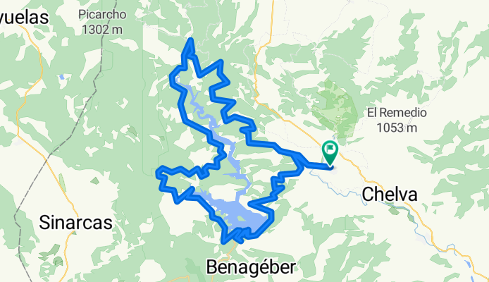
- TRIALERAS DEL PANTANO DE BENAGÉBER
- BERCUTA y TARTALONA
- 29.9 km
- 647 m
- 646 m
- Tuéjar, Valencia, Spain
- BARRANCO EL FRAYLE - BUENALECHE
- 22.5 km
- 910 m
- 909 m
- Tuéjar, Valencia, Spain
- SOLANA CARRERAS Y SENDA ANDARIEL
- 10.3 km
- 330 m
- 330 m
- Tuéjar, Valencia, Spain
- QUEDADA STUMPJUMPER 2010 FOROMTB
- 32.6 km
- 793 m
- 793 m
- Tuéjar, Valencia, Spain
- Ahillas - Alcotas - La Yesa - Alpuente - Arquela
- 58 km
- 843 m
- 839 m
- Tuéjar, Valencia, Spain
- CORRALEJOS ARQUELA
- 26.1 km
- 412 m
- 412 m
- Tuéjar, Valencia, Spain
- LA PUENTE ALTA Y EL CASTILLO DE DOMEÑO
- 38.3 km
- 1,142 m
- 1,239 m
- Tuéjar, Valencia, Spain
Open it in the app


