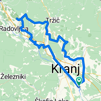
- 79.3 km
- 1,091 m
- 1,089 m
- Hrastje, Občina Šenčur, Slovenia
Drulovka - Sv. Jost, Kranj
A cycling route starting in Hrastje, Občina Šenčur, Slovenia.
Overview
About this route
<div style="background-image: initial; background-attachment: initial; background-origin: initial; background-clip: initial; background-color: #ffffff; color: #535353; font-family: Verdana, Arial, Helvetica, sans-serif; font-size: 10px; margin: 8px;">
Večinoma ravninska po cesti skozi Orehek in Stražišče. Vzpon strm (mestoma 15%). Lep razgled z vrha s cerkvico in okrepčevalnico.
</div>
- -:--
- Duration
- 19.5 km
- Distance
- 486 m
- Ascent
- 486 m
- Descent
- ---
- Avg. speed
- ---
- Max. altitude
created this 14 years ago
Route quality
Waytypes & surfaces along the route
Waytypes
Road
15.2 km
(78 %)
Quiet road
3.1 km
(16 %)
Surfaces
Paved
15.8 km
(81 %)
Unpaved
0.2 km
(1 %)
Asphalt
13.6 km
(70 %)
Paved (undefined)
2.1 km
(11 %)
Continue with Bikemap
Use, edit, or download this cycling route
You would like to ride Drulovka - Sv. Jost, Kranj or customize it for your own trip? Here is what you can do with this Bikemap route:
Free features
- Save this route as favorite or in collections
- Copy & plan your own version of this route
- Sync your route with Garmin or Wahoo
Premium features
Free trial for 3 days, or one-time payment. More about Bikemap Premium.
- Navigate this route on iOS & Android
- Export a GPX / KML file of this route
- Create your custom printout (try it for free)
- Download this route for offline navigation
Discover more Premium features.
Get Bikemap PremiumFrom our community
Other popular routes starting in Hrastje
- Sobota Begunje
- Drulovka - farma - Orehek - Drulovka (tekaška)
- 9.5 km
- 40 m
- 42 m
- Hrastje, Občina Šenčur, Slovenia
- Voglje to Trboje
- 89.1 km
- 2,246 m
- 2,252 m
- Hrastje, Občina Šenčur, Slovenia
- Drulovka - Sv. Jost, Kranj
- 19.5 km
- 486 m
- 486 m
- Hrastje, Občina Šenčur, Slovenia
- Above the fog MTB
- 35.7 km
- 1,051 m
- 1,052 m
- Hrastje, Občina Šenčur, Slovenia
- From Šenčur to Ponikva
- 100.9 km
- 1,275 m
- 1,314 m
- Hrastje, Občina Šenčur, Slovenia
- Trboje - Petrovo brdo - sorica - Bled - Trboje
- 129.4 km
- 1,170 m
- 1,172 m
- Hrastje, Občina Šenčur, Slovenia
- Kranj-Zelezniki-Sorica-Bohinj-Bled-Kranj
- 119.2 km
- 1,099 m
- 1,099 m
- Hrastje, Občina Šenčur, Slovenia
Open it in the app


