

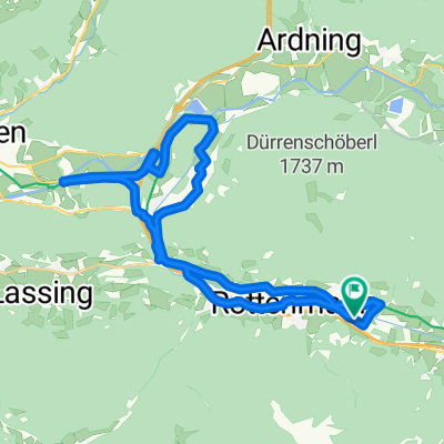
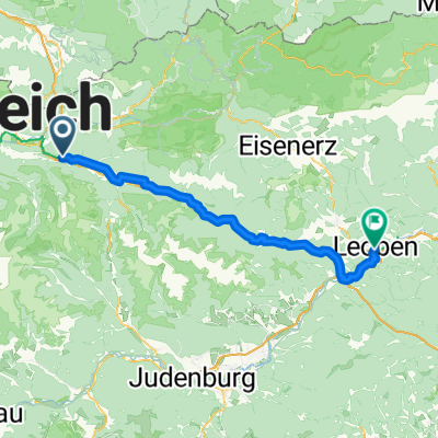
Leoben Selzthal
A cycling route starting in Rottenmann, Styria, Austria.
Overview
About this route
- -:--
- Duration
- 74 km
- Distance
- 691 m
- Ascent
- 793 m
- Descent
- ---
- Avg. speed
- 877 m
- Max. altitude

Route quality
Waytypes & surfaces along the route
Waytypes
Quiet road
57 km
(77 %)
Access road
2.2 km
(3 %)
Surfaces
Paved
21.4 km
(29 %)
Unpaved
2.2 km
(3 %)
Asphalt
21.4 km
(29 %)
Gravel
2.2 km
(3 %)
Undefined
50.3 km
(68 %)
Continue with Bikemap
Use, edit, or download this cycling route
You would like to ride Leoben Selzthal or customize it for your own trip? Here is what you can do with this Bikemap route:
Free features
- Save this route as favorite or in collections
- Copy & plan your own version of this route
- Sync your route with Garmin or Wahoo
Premium features
Free trial for 3 days, or one-time payment. More about Bikemap Premium.
- Navigate this route on iOS & Android
- Export a GPX / KML file of this route
- Create your custom printout (try it for free)
- Download this route for offline navigation
Discover more Premium features.
Get Bikemap PremiumFrom our community
Other popular routes starting in Rottenmann
 Rottenmann-Gaishorner See
- Distance
- 42.4 km
- Ascent
- 244 m
- Descent
- 240 m
- Location
- Rottenmann, Styria, Austria
 Hauptstraße 60, Rottenmann nach R2 Murradweg 29, Sankt Michael in der Obersteiermark
- Distance
- 67.8 km
- Ascent
- 602 m
- Descent
- 696 m
- Location
- Rottenmann, Styria, Austria
 Sankt Georgen 46a, Sankt Georgen nach Sankt Georgen 46a, Sankt Georgen
- Distance
- 30.6 km
- Ascent
- 328 m
- Descent
- 256 m
- Location
- Rottenmann, Styria, Austria
 EV14 Leg 3: Rottenmann - Leoben
- Distance
- 80.3 km
- Ascent
- 897 m
- Descent
- 1,026 m
- Location
- Rottenmann, Styria, Austria
 Leoben Selzthal
- Distance
- 74 km
- Ascent
- 691 m
- Descent
- 793 m
- Location
- Rottenmann, Styria, Austria
 Rottenmann-Admont-St.Gallen-Großraming-Steyr-Prbk
- Distance
- 163.9 km
- Ascent
- 1,073 m
- Descent
- 1,377 m
- Location
- Rottenmann, Styria, Austria
 Strechau, Rottenmann nach Österreichische Romantikstraße, Aigen im Ennstal
- Distance
- 13.2 km
- Ascent
- 135 m
- Descent
- 155 m
- Location
- Rottenmann, Styria, Austria
 Donnersbachwald - Rottenmann
- Distance
- 40 km
- Ascent
- 568 m
- Descent
- 295 m
- Location
- Rottenmann, Styria, Austria
Open it in the app