
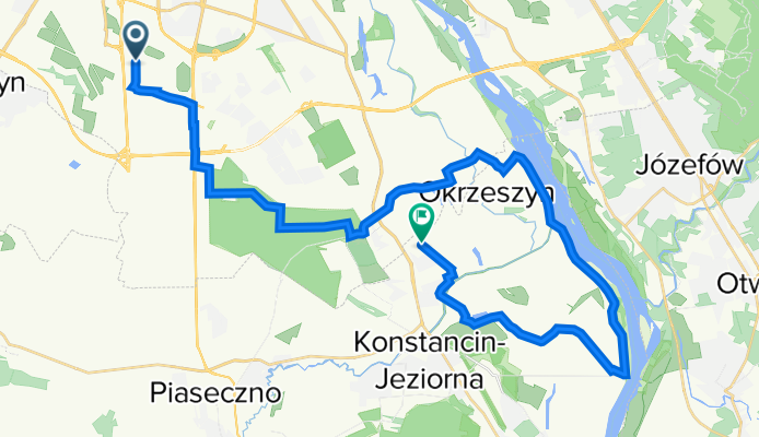
New road
A cycling route starting in Włochy, Masovian Voivodeship, Poland.
Overview
About this route
- -:--
- Duration
- 35.1 km
- Distance
- 50 m
- Ascent
- 66 m
- Descent
- ---
- Avg. speed
- 123 m
- Avg. speed
Route quality
Waytypes & surfaces along the route
Waytypes
Road
13.3 km
(38 %)
Quiet road
11.2 km
(32 %)
Surfaces
Paved
32.5 km
(93 %)
Unpaved
1.6 km
(5 %)
Asphalt
28.5 km
(81 %)
Paved (undefined)
2.9 km
(8 %)
Continue with Bikemap
Use, edit, or download this cycling route
You would like to ride New road or customize it for your own trip? Here is what you can do with this Bikemap route:
Free features
- Save this route as favorite or in collections
- Copy & plan your own version of this route
- Sync your route with Garmin or Wahoo
Premium features
Free trial for 3 days, or one-time payment. More about Bikemap Premium.
- Navigate this route on iOS & Android
- Export a GPX / KML file of this route
- Create your custom printout (try it for free)
- Download this route for offline navigation
Discover more Premium features.
Get Bikemap PremiumFrom our community
Other popular routes starting in Włochy
 Śladem fortów wojskowych 2
- Distance
- 29.8 km
- Ascent
- 24 m
- Descent
- 24 m
- Location
- Włochy, Masovian Voivodeship, Poland
 Kampinos
- Distance
- 85 km
- Ascent
- 71 m
- Descent
- 70 m
- Location
- Włochy, Masovian Voivodeship, Poland
 Sobota 22.08
- Distance
- 111.8 km
- Ascent
- 116 m
- Descent
- 117 m
- Location
- Włochy, Masovian Voivodeship, Poland
 Aleje Jerozolimskie 202A, Warszawa do Krańcowa 57, Warszawa
- Distance
- 10.6 km
- Ascent
- 74 m
- Descent
- 83 m
- Location
- Włochy, Masovian Voivodeship, Poland
 Łazienki
- Distance
- 16.3 km
- Ascent
- 53 m
- Descent
- 53 m
- Location
- Włochy, Masovian Voivodeship, Poland
 Warszawa-Kazimierz Dolny
- Distance
- 149.3 km
- Ascent
- 97 m
- Descent
- 79 m
- Location
- Włochy, Masovian Voivodeship, Poland
 Magdalenka
- Distance
- 38.3 km
- Ascent
- 52 m
- Descent
- 53 m
- Location
- Włochy, Masovian Voivodeship, Poland
 Śladem okolicznych fortów wojskowych III
- Distance
- 36.3 km
- Ascent
- 67 m
- Descent
- 66 m
- Location
- Włochy, Masovian Voivodeship, Poland
Open it in the app