

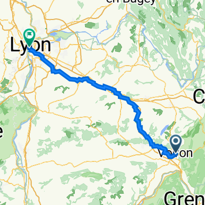
1–19 Place du Général Leclerc, Voiron à 3 Chemin des Bouleaux, Saint-Cassien
A cycling route starting in Voiron, Auvergne-Rhône-Alpes, France.
Overview
About this route
- 19 min
- Duration
- 4 km
- Distance
- 89 m
- Ascent
- 13 m
- Descent
- 12.3 km/h
- Avg. speed
- 375 m
- Max. altitude
Route quality
Waytypes & surfaces along the route
Waytypes
Quiet road
1.3 km
(32 %)
Access road
0.1 km
(3 %)
Surfaces
Paved
3 km
(76 %)
Unpaved
0.1 km
(2 %)
Asphalt
3 km
(76 %)
Gravel
0.1 km
(2 %)
Undefined
0.9 km
(22 %)
Continue with Bikemap
Use, edit, or download this cycling route
You would like to ride 1–19 Place du Général Leclerc, Voiron à 3 Chemin des Bouleaux, Saint-Cassien or customize it for your own trip? Here is what you can do with this Bikemap route:
Free features
- Save this route as favorite or in collections
- Copy & plan your own version of this route
- Sync your route with Garmin or Wahoo
Premium features
Free trial for 3 days, or one-time payment. More about Bikemap Premium.
- Navigate this route on iOS & Android
- Export a GPX / KML file of this route
- Create your custom printout (try it for free)
- Download this route for offline navigation
Discover more Premium features.
Get Bikemap PremiumFrom our community
Other popular routes starting in Voiron
 7e deel 113km naar Alp d'Huez (eind)
- Distance
- 89.7 km
- Ascent
- 1,716 m
- Descent
- 277 m
- Location
- Voiron, Auvergne-Rhône-Alpes, France
 BRChartreuse
- Distance
- 147.9 km
- Ascent
- 2,791 m
- Descent
- 2,856 m
- Location
- Voiron, Auvergne-Rhône-Alpes, France
 37 Boulevard Franklin Roosevelt, Voiron to 28 Rue Vaubecour, Lyon
- Distance
- 96.4 km
- Ascent
- 721 m
- Descent
- 839 m
- Location
- Voiron, Auvergne-Rhône-Alpes, France
 Grande Sure par la Charmette
- Distance
- 73 km
- Ascent
- 2,073 m
- Descent
- 2,147 m
- Location
- Voiron, Auvergne-Rhône-Alpes, France
 Col d'Emile
- Distance
- 38.6 km
- Ascent
- 669 m
- Descent
- 669 m
- Location
- Voiron, Auvergne-Rhône-Alpes, France
 Rando des dix communes 2012
- Distance
- 64 km
- Ascent
- 737 m
- Descent
- 737 m
- Location
- Voiron, Auvergne-Rhône-Alpes, France
 Petit bouche en Chartreuse au départ de Voiron
- Distance
- 47.4 km
- Ascent
- 756 m
- Descent
- 752 m
- Location
- Voiron, Auvergne-Rhône-Alpes, France
 Voiron-Aiguebellette
- Distance
- 118 km
- Ascent
- 1,378 m
- Descent
- 1,378 m
- Location
- Voiron, Auvergne-Rhône-Alpes, France
Open it in the app