

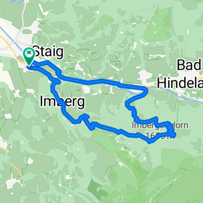
Sonthofen Zwölferkopf runde mit Schönem Trail CLONED FROM ROUTE 244342
A cycling route starting in Sonthofen, Bavaria, Germany.
Overview
About this route
Approximately 680 m of elevation gain. Asphalt uphill and then various downhill trails at the Hindelanger Hornbahn to choose from. My route is the medium difficulty descent. Have fun!
- -:--
- Duration
- 16.2 km
- Distance
- 707 m
- Ascent
- 707 m
- Descent
- ---
- Avg. speed
- ---
- Max. altitude
Continue with Bikemap
Use, edit, or download this cycling route
You would like to ride Sonthofen Zwölferkopf runde mit Schönem Trail CLONED FROM ROUTE 244342 or customize it for your own trip? Here is what you can do with this Bikemap route:
Free features
- Save this route as favorite or in collections
- Copy & plan your own version of this route
- Sync your route with Garmin or Wahoo
Premium features
Free trial for 3 days, or one-time payment. More about Bikemap Premium.
- Navigate this route on iOS & Android
- Export a GPX / KML file of this route
- Create your custom printout (try it for free)
- Download this route for offline navigation
Discover more Premium features.
Get Bikemap PremiumFrom our community
Other popular routes starting in Sonthofen
 Vom Ostrachtal zur Alp Mitterhaus (1081 m)
- Distance
- 20.5 km
- Ascent
- 415 m
- Descent
- 415 m
- Location
- Sonthofen, Bavaria, Germany
 Mein erster Alpenpass
- Distance
- 5.8 km
- Ascent
- 308 m
- Descent
- 35 m
- Location
- Sonthofen, Bavaria, Germany
 Sonthofen Zwölferkopf runde mit Schönem Trail CLONED FROM ROUTE 244342
- Distance
- 16.2 km
- Ascent
- 707 m
- Descent
- 707 m
- Location
- Sonthofen, Bavaria, Germany
 Bergkäs Runde Oberallgäu - Bregenzer Wald
- Distance
- 71.3 km
- Ascent
- 987 m
- Descent
- 989 m
- Location
- Sonthofen, Bavaria, Germany
 D_SüdBayern_Sonthofen: "Allgaeu Panorama Marathon"
- Distance
- 41.5 km
- Ascent
- 1,134 m
- Descent
- 1,133 m
- Location
- Sonthofen, Bavaria, Germany
 Route von Landgasthof Post - Gasthof Zum Löwen
- Distance
- 30.5 km
- Ascent
- 594 m
- Descent
- 467 m
- Location
- Sonthofen, Bavaria, Germany
 Route zu Giebelhaus
- Distance
- 12.7 km
- Ascent
- 709 m
- Descent
- 244 m
- Location
- Sonthofen, Bavaria, Germany
 Sonthofen - Immenstadt - Untermaiselstein - Runde
- Distance
- 37.5 km
- Ascent
- 186 m
- Descent
- 183 m
- Location
- Sonthofen, Bavaria, Germany
Open it in the app