

Overview
About this route
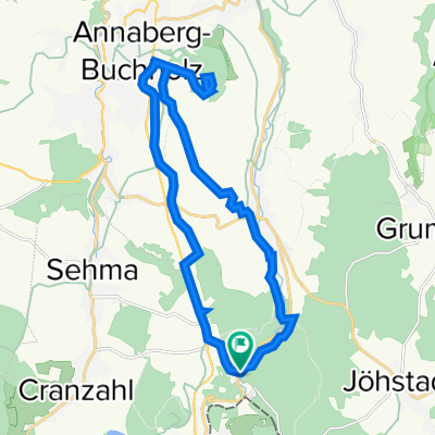
From Hotel Fichtenhäusel to Oberwiesenthal
- -:--
- Duration
- 32.5 km
- Distance
- 596 m
- Ascent
- 599 m
- Descent
- ---
- Avg. speed
- 985 m
- Max. altitude

Part of
Gästetouren
6 stages
Route quality
Waytypes & surfaces along the route
Waytypes
Quiet road
11.1 km
(34 %)
Track
5.2 km
(16 %)
Surfaces
Paved
22.8 km
(70 %)
Unpaved
2.9 km
(9 %)
Asphalt
22.8 km
(70 %)
Gravel
2 km
(6 %)
Continue with Bikemap
Use, edit, or download this cycling route
You would like to ride Oberwiesenthal & Fichtelberg or customize it for your own trip? Here is what you can do with this Bikemap route:
Free features
- Save this route as favorite or in collections
- Copy & plan your own version of this route
- Sync your route with Garmin or Wahoo
Premium features
Free trial for 3 days, or one-time payment. More about Bikemap Premium.
- Navigate this route on iOS & Android
- Export a GPX / KML file of this route
- Create your custom printout (try it for free)
- Download this route for offline navigation
Discover more Premium features.
Get Bikemap PremiumFrom our community
Other popular routes starting in Bärenstein
 Annaberg-Buchholz & Pöhlberg
- Distance
- 20.6 km
- Ascent
- 475 m
- Descent
- 476 m
- Location
- Bärenstein, Saxony, Germany
 Pressnitztal(bahn)
- Distance
- 21.5 km
- Ascent
- 559 m
- Descent
- 557 m
- Location
- Bärenstein, Saxony, Germany
 Rund um den Fichtelberg
- Distance
- 62.1 km
- Ascent
- 916 m
- Descent
- 910 m
- Location
- Bärenstein, Saxony, Germany
 Fichtenhäusel- Keilberg - Fichtenhäusel
- Distance
- 38.5 km
- Ascent
- 720 m
- Descent
- 719 m
- Location
- Bärenstein, Saxony, Germany
 Fichtenhäusel-Zigeunerfelsen - Preßnitztal- Veipert - Fichtenhäusel
- Distance
- 38.5 km
- Ascent
- 787 m
- Descent
- 785 m
- Location
- Bärenstein, Saxony, Germany
 Fichtenhäusel Spezial
- Distance
- 49.1 km
- Ascent
- 1,174 m
- Descent
- 1,172 m
- Location
- Bärenstein, Saxony, Germany
 Umleitungsempfehlung Fichtelberg-Bärenstein
- Distance
- 2.1 km
- Ascent
- 52 m
- Descent
- 73 m
- Location
- Bärenstein, Saxony, Germany
 Oberwiesenthal & Fichtelberg
- Distance
- 32.5 km
- Ascent
- 596 m
- Descent
- 599 m
- Location
- Bärenstein, Saxony, Germany
Open it in the app