

Zacamulpa - Ameyalco
A cycling route starting in Santa Cruz Huitzizilapan, State of Mexico, Mexico.
Overview
About this route
- 1 h 16 min
- Duration
- 16.1 km
- Distance
- 131 m
- Ascent
- 353 m
- Descent
- 12.7 km/h
- Avg. speed
- 2,824 m
- Max. altitude

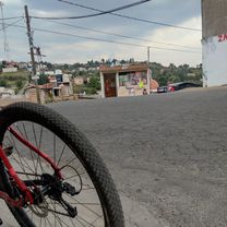
Route photos


Route quality
Waytypes & surfaces along the route
Waytypes
Busy road
13.1 km
(81 %)
Road
2.2 km
(14 %)
Surfaces
Paved
16 km
(99 %)
Asphalt
13.4 km
(83 %)
Paved (undefined)
2.6 km
(16 %)
Undefined
0.1 km
(<1 %)
Continue with Bikemap
Use, edit, or download this cycling route
You would like to ride Zacamulpa - Ameyalco or customize it for your own trip? Here is what you can do with this Bikemap route:
Free features
- Save this route as favorite or in collections
- Copy & plan your own version of this route
- Sync your route with Garmin or Wahoo
Premium features
Free trial for 3 days, or one-time payment. More about Bikemap Premium.
- Navigate this route on iOS & Android
- Export a GPX / KML file of this route
- Create your custom printout (try it for free)
- Download this route for offline navigation
Discover more Premium features.
Get Bikemap PremiumFrom our community
Other popular routes starting in Santa Cruz Huitzizilapan
 Zacamulpa - Ameyalco
- Distance
- 16.1 km
- Ascent
- 131 m
- Descent
- 353 m
- Location
- Santa Cruz Huitzizilapan, State of Mexico, Mexico
Open it in the app