
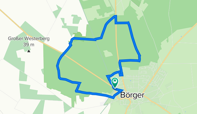
Wacholderpatt - Wacholderpatt
A cycling route starting in Börger, Lower Saxony, Germany.
Overview
About this route
These GPS data are the property of the geo-coaching project and are intended exclusively for private use. Commercial use is not permitted without authorization.
- -:--
- Duration
- 9.5 km
- Distance
- 39 m
- Ascent
- 38 m
- Descent
- ---
- Avg. speed
- 50 m
- Max. altitude

Route quality
Waytypes & surfaces along the route
Waytypes
Track
6.3 km
(67 %)
Path
1.8 km
(19 %)
Surfaces
Paved
0.9 km
(9 %)
Unpaved
8 km
(85 %)
Ground
6.3 km
(66 %)
Sand
1.7 km
(18 %)
Continue with Bikemap
Use, edit, or download this cycling route
You would like to ride Wacholderpatt - Wacholderpatt or customize it for your own trip? Here is what you can do with this Bikemap route:
Free features
- Save this route as favorite or in collections
- Copy & plan your own version of this route
- Sync your route with Garmin or Wahoo
Premium features
Free trial for 3 days, or one-time payment. More about Bikemap Premium.
- Navigate this route on iOS & Android
- Export a GPX / KML file of this route
- Create your custom printout (try it for free)
- Download this route for offline navigation
Discover more Premium features.
Get Bikemap PremiumFrom our community
Other popular routes starting in Börger
 Dünenweg 2A nach Dünenweg 2A
- Distance
- 20.9 km
- Ascent
- 110 m
- Descent
- 52 m
- Location
- Börger, Lower Saxony, Germany
 Helter Damm 11a nach Helter Damm 11a
- Distance
- 18.4 km
- Ascent
- 44 m
- Descent
- 111 m
- Location
- Börger, Lower Saxony, Germany
 Helter Damm 11a nach Helter Damm 11a
- Distance
- 21.2 km
- Ascent
- 93 m
- Descent
- 105 m
- Location
- Börger, Lower Saxony, Germany
 Tannenkamp
- Distance
- 27.5 km
- Ascent
- 88 m
- Descent
- 87 m
- Location
- Börger, Lower Saxony, Germany
 Wacholderpatt - Wacholderpatt
- Distance
- 9.5 km
- Ascent
- 39 m
- Descent
- 38 m
- Location
- Börger, Lower Saxony, Germany
 Dünenweg 2A nach Helter Damm 11a
- Distance
- 21.5 km
- Ascent
- 72 m
- Descent
- 106 m
- Location
- Börger, Lower Saxony, Germany
 Helter Damm 11a nach Dünenweg 2A
- Distance
- 24.1 km
- Ascent
- 69 m
- Descent
- 93 m
- Location
- Börger, Lower Saxony, Germany
 Up'n Riegen 8, Börger nach Up'n Riegen 8, Börger
- Distance
- 16.4 km
- Ascent
- 82 m
- Descent
- 81 m
- Location
- Börger, Lower Saxony, Germany
Open it in the app