
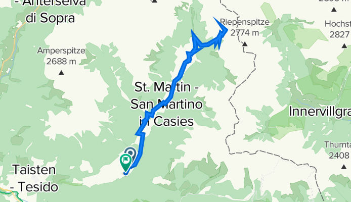
Pichl-Almweg
A cycling route starting in Valle di Casies - Gsies, Trentino-Alto Adige, Italy.
Overview
About this route
- 4 h 3 min
- Duration
- 33.6 km
- Distance
- 1,148 m
- Ascent
- 1,113 m
- Descent
- 8.3 km/h
- Avg. speed
- 2,125 m
- Max. altitude

Route photos

Route quality
Waytypes & surfaces along the route
Waytypes
Track
17.8 km
(53 %)
Quiet road
12.1 km
(36 %)
Surfaces
Paved
9.1 km
(27 %)
Unpaved
17.8 km
(53 %)
Gravel
15.1 km
(45 %)
Asphalt
8.1 km
(24 %)
Continue with Bikemap
Use, edit, or download this cycling route
You would like to ride Pichl-Almweg or customize it for your own trip? Here is what you can do with this Bikemap route:
Free features
- Save this route as favorite or in collections
- Copy & plan your own version of this route
- Sync your route with Garmin or Wahoo
Premium features
Free trial for 3 days, or one-time payment. More about Bikemap Premium.
- Navigate this route on iOS & Android
- Export a GPX / KML file of this route
- Create your custom printout (try it for free)
- Download this route for offline navigation
Discover more Premium features.
Get Bikemap PremiumFrom our community
Other popular routes starting in Valle di Casies - Gsies
 Puregg 2A, Planca di Sotto nach Puregg 2B, Planca di Sotto
- Distance
- 14.5 km
- Ascent
- 588 m
- Descent
- 552 m
- Location
- Valle di Casies - Gsies, Trentino-Alto Adige, Italy
 Über dem Pustetal
- Distance
- 25.8 km
- Ascent
- 704 m
- Descent
- 704 m
- Location
- Valle di Casies - Gsies, Trentino-Alto Adige, Italy
 H.Stoll - Welsberg - H.Stoll
- Distance
- 31 km
- Ascent
- 565 m
- Descent
- 565 m
- Location
- Valle di Casies - Gsies, Trentino-Alto Adige, Italy
 Pichl-Almweg
- Distance
- 33.6 km
- Ascent
- 1,148 m
- Descent
- 1,113 m
- Location
- Valle di Casies - Gsies, Trentino-Alto Adige, Italy
 Dolomity giro
- Distance
- 213.8 km
- Ascent
- 2,130 m
- Descent
- 1,556 m
- Location
- Valle di Casies - Gsies, Trentino-Alto Adige, Italy
 Pichl-Antholzer See-Pichl
- Distance
- 73.8 km
- Ascent
- 1,226 m
- Descent
- 1,226 m
- Location
- Valle di Casies - Gsies, Trentino-Alto Adige, Italy
 Gsiesertalrunde
- Distance
- 36.8 km
- Ascent
- 752 m
- Descent
- 752 m
- Location
- Valle di Casies - Gsies, Trentino-Alto Adige, Italy
 Gsies-Antholz
- Distance
- 26.6 km
- Ascent
- 492 m
- Descent
- 479 m
- Location
- Valle di Casies - Gsies, Trentino-Alto Adige, Italy
Open it in the app