

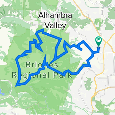
1941 Buttner Rd, Pleasant Hill to 1941 Buttner Rd, Pleasant Hill
A cycling route starting in Pleasant Hill, California, United States.
Overview
About this route
- 1 h 20 min
- Duration
- 27.3 km
- Distance
- 1,050 m
- Ascent
- 1,053 m
- Descent
- 20.5 km/h
- Avg. speed
- 439 m
- Max. altitude
Continue with Bikemap
Use, edit, or download this cycling route
You would like to ride 1941 Buttner Rd, Pleasant Hill to 1941 Buttner Rd, Pleasant Hill or customize it for your own trip? Here is what you can do with this Bikemap route:
Free features
- Save this route as favorite or in collections
- Copy & plan your own version of this route
- Sync your route with Garmin or Wahoo
Premium features
Free trial for 3 days, or one-time payment. More about Bikemap Premium.
- Navigate this route on iOS & Android
- Export a GPX / KML file of this route
- Create your custom printout (try it for free)
- Download this route for offline navigation
Discover more Premium features.
Get Bikemap PremiumFrom our community
Other popular routes starting in Pleasant Hill
 Short bike tour through Pleasant Hill
- Distance
- 0.9 km
- Ascent
- 8 m
- Descent
- 8 m
- Location
- Pleasant Hill, California, United States
 1941 Buttner Rd, Pleasant Hill to 1941 Buttner Rd, Pleasant Hill
- Distance
- 27.3 km
- Ascent
- 1,050 m
- Descent
- 1,053 m
- Location
- Pleasant Hill, California, United States
 Briones from Taylor
- Distance
- 16.6 km
- Ascent
- 491 m
- Descent
- 417 m
- Location
- Pleasant Hill, California, United States
 Brief ride from Pleasant Hill to Walnut Creek
- Distance
- 6.6 km
- Ascent
- 17 m
- Descent
- 7 m
- Location
- Pleasant Hill, California, United States
 928 Dartmouth Way, Concord to 1596 Nuala St, Concord
- Distance
- 21.6 km
- Ascent
- 86 m
- Descent
- 85 m
- Location
- Pleasant Hill, California, United States
 Walnut Creek 3 Bears
- Distance
- 55.4 km
- Ascent
- 543 m
- Descent
- 544 m
- Location
- Pleasant Hill, California, United States
 jfngf
jfngf- Distance
- 15.3 km
- Ascent
- 791 m
- Descent
- 718 m
- Location
- Pleasant Hill, California, United States
 Iron Horse Regional Trail, Concord to 340 Lexington Dr, Vallejo
- Distance
- 25.2 km
- Ascent
- 267 m
- Descent
- 238 m
- Location
- Pleasant Hill, California, United States
Open it in the app