

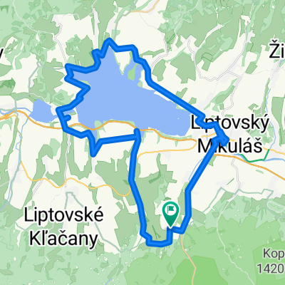
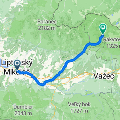
LIPTOVSKÝ MIKULÁŠ:-Podbreziny.Lip.Ondrej-Pol.letisko-Račková dol.-Hotel Mier-lúky Jakubovia-Jakubovany-Lip.Ondrej-Benadiková-Podbreziny CLONED FROM ROUTE 100008
A cycling route starting in Liptovský Mikuláš, Žilina Region, Slovakia.
Overview
About this route
The trail connects two routes, one across the field airport and the other through the Jakubovian valley. Both converge in the Račkov valley. We have eliminated the route along the busy road from Pribilina and L. Hrádok up to the turnoff to Benadiková. It is a connection where you can see the Západné Tatry mountains, and for half of the way, we are accompanied by the view of the Vysoké Tatry and the majestic Kriváň. The views of the Nízke Tatry are not to be despised either. In good weather, you might even see Kráľová Hola in the distance. There are two critical points on the route, at least for me, from Lip. Ondrej up to the field airport, and the second is to the hotel Mier in the Račkov valley; it's quite steep, but it can be managed even with some push on the bike. After crossing the meadow, you just need to brake here and there and not even pedal hard until Benadiková. I wish everyone to enjoy this trail and reach their destination without injury or issues!!
- -:--
- Duration
- 30.8 km
- Distance
- 405 m
- Ascent
- 406 m
- Descent
- ---
- Avg. speed
- ---
- Max. altitude
Route highlights
Points of interest along the route

Photo after 6.5 km
Koniec dediny Lip.Ondrej

Photo after 7.7 km

Photo after 8.2 km

Photo after 11.3 km
Za lesným strediskom .

Photo after 12.4 km
Polno-lesná cesta

Photo after 13.4 km

Photo after 13.8 km
vpozadí vodáren

Photo after 15.1 km
Posledné strmé stúpanie

Photo after 16 km
už nohy odmietajú poslušnost,už len kúsok a vezieme sa len dolu

Point of interest after 16.4 km
Vodný zdroj v pozadí

Photo after 16.5 km
To je pohoda ide dolu brehom !

Photo after 17 km
Piknik

Photo after 17.6 km
Osamelá chatka.

Photo after 18.5 km
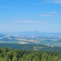
Panoráma na : N.TATRY

Photo after 18.7 km
Osamelý smrek na lúke

Photo after 19.3 km
Záber ešťe zo zimnej túry peši

Photo after 26.3 km
Pohľad na vzdialenú VETERNÚ
Continue with Bikemap
Use, edit, or download this cycling route
You would like to ride LIPTOVSKÝ MIKULÁŠ:-Podbreziny.Lip.Ondrej-Pol.letisko-Račková dol.-Hotel Mier-lúky Jakubovia-Jakubovany-Lip.Ondrej-Benadiková-Podbreziny CLONED FROM ROUTE 100008 or customize it for your own trip? Here is what you can do with this Bikemap route:
Free features
- Save this route as favorite or in collections
- Copy & plan your own version of this route
- Sync your route with Garmin or Wahoo
Premium features
Free trial for 3 days, or one-time payment. More about Bikemap Premium.
- Navigate this route on iOS & Android
- Export a GPX / KML file of this route
- Create your custom printout (try it for free)
- Download this route for offline navigation
Discover more Premium features.
Get Bikemap PremiumFrom our community
Other popular routes starting in Liptovský Mikuláš
 LM-2018-05-07
- Distance
- 29.6 km
- Ascent
- 537 m
- Descent
- 537 m
- Location
- Liptovský Mikuláš, Žilina Region, Slovakia
 Liptovský Mikuláš,Čierny Váh a späť.
- Distance
- 77.7 km
- Ascent
- 1,037 m
- Descent
- 1,085 m
- Location
- Liptovský Mikuláš, Žilina Region, Slovakia
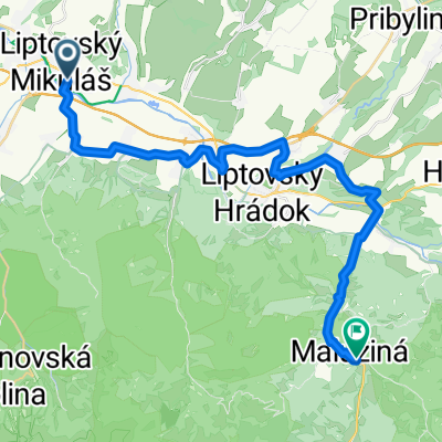 LM- Lipt. Hrádok - Kráľova Lehota- Malužiná
- Distance
- 28.6 km
- Ascent
- 676 m
- Descent
- 508 m
- Location
- Liptovský Mikuláš, Žilina Region, Slovakia
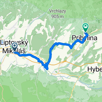 LM- Podtureň- Jamník- Pribilina
- Distance
- 23 km
- Ascent
- 3,715 m
- Descent
- 3,498 m
- Location
- Liptovský Mikuláš, Žilina Region, Slovakia
 Pavčina Lehota do Pavčina Lehota
- Distance
- 49 km
- Ascent
- 510 m
- Descent
- 552 m
- Location
- Liptovský Mikuláš, Žilina Region, Slovakia
 LM- Lipt.Hrádok- L.Kokava- Podbanské- Kôprová dolina
- Distance
- 37.3 km
- Ascent
- 684 m
- Descent
- 69 m
- Location
- Liptovský Mikuláš, Žilina Region, Slovakia
 LM- Lipt.Hrádok- Kráľ.Lehota- Východná
- Distance
- 35.9 km
- Ascent
- 1,047 m
- Descent
- 811 m
- Location
- Liptovský Mikuláš, Žilina Region, Slovakia
 LM- Bobrovec- Biela Skala- Zuberec- Zverovka /Spálená
- Distance
- 44.6 km
- Ascent
- 1,440 m
- Descent
- 972 m
- Location
- Liptovský Mikuláš, Žilina Region, Slovakia
Open it in the app