

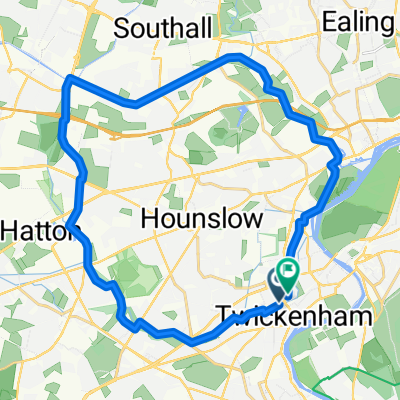
BfCiC 2022 Twicks - Hove
A cycling route starting in Twickenham, England, United Kingdom.
Overview
About this route
TWICKENHAM to HOVE (Hove Station) 95.7km = 58m. Climb 2690ft /
COFFEE; HEADLEY, Village Hall Stores 23k/14m.
LUNCH; NEWDIGATE, The Six Bells Pub 43k/27m.
TEA ; WARNINGLID, The Half Moon Pub 64k/40m.
LOO STOP; Rushfield GrdCentre 81k/50m.
- -:--
- Duration
- 93.2 km
- Distance
- 1,008 m
- Ascent
- 990 m
- Descent
- ---
- Avg. speed
- 199 m
- Max. altitude

Route quality
Waytypes & surfaces along the route
Waytypes
Quiet road
42.9 km
(46 %)
Road
29.8 km
(32 %)
Surfaces
Paved
46.6 km
(50 %)
Unpaved
0.9 km
(1 %)
Asphalt
45.7 km
(49 %)
Paved (undefined)
0.9 km
(1 %)
Route highlights
Points of interest along the route
Point of interest after 25.3 km
COFFEE Headley Village Hall Stores
Point of interest after 45.4 km
LUNCH - Newdigate, The Six Bells Pub
Point of interest after 68.2 km
TEA - ...... The Half Moon Pub
Point of interest after 82.2 km
Rashfield Garden Centre at 82km/50m Loo Stop and OR > Carry on for quick end at Brighton
Point of interest after 85.7 km
Devil's Dike Summit REST STOP - Dike Golf Club
Point of interest after 93.2 km
FINISH - Brighton Station
Continue with Bikemap
Use, edit, or download this cycling route
You would like to ride BfCiC 2022 Twicks - Hove or customize it for your own trip? Here is what you can do with this Bikemap route:
Free features
- Save this route as favorite or in collections
- Copy & plan your own version of this route
- Split it into stages to create a multi-day tour
- Sync your route with Garmin or Wahoo
Premium features
Free trial for 3 days, or one-time payment. More about Bikemap Premium.
- Navigate this route on iOS & Android
- Export a GPX / KML file of this route
- Create your custom printout (try it for free)
- Download this route for offline navigation
Discover more Premium features.
Get Bikemap PremiumFrom our community
Other popular routes starting in Twickenham
 Crane River-Cranford-U.Canal-Brentford Ring
- Distance
- 25.8 km
- Ascent
- 46 m
- Descent
- 45 m
- Location
- Twickenham, England, United Kingdom
 BfCiC 2025 Twickenham - Hove
- Distance
- 93.2 km
- Ascent
- 981 m
- Descent
- 964 m
- Location
- Twickenham, England, United Kingdom
 bumps to box hill
- Distance
- 92.3 km
- Ascent
- 594 m
- Descent
- 593 m
- Location
- Twickenham, England, United Kingdom
 bfcic2021; Twickenham - Brighton 94km/57m
- Distance
- 93.9 km
- Ascent
- 615 m
- Descent
- 581 m
- Location
- Twickenham, England, United Kingdom
 Test 1
- Distance
- 23.8 km
- Ascent
- 43 m
- Descent
- 42 m
- Location
- Twickenham, England, United Kingdom
 Woodville Road, Richmond to Ham Gate Avenue, Richmond
- Distance
- 2.3 km
- Ascent
- 13 m
- Descent
- 13 m
- Location
- Twickenham, England, United Kingdom
 Whitton Road to Waterman Street 26A
- Distance
- 11 km
- Ascent
- 28 m
- Descent
- 74 m
- Location
- Twickenham, England, United Kingdom
 bfcic: Twicks - Windsor - W.Drayton(Canal) 2 Brentford - Twicks
- Distance
- 68.3 km
- Ascent
- 90 m
- Descent
- 91 m
- Location
- Twickenham, England, United Kingdom
Open it in the app