

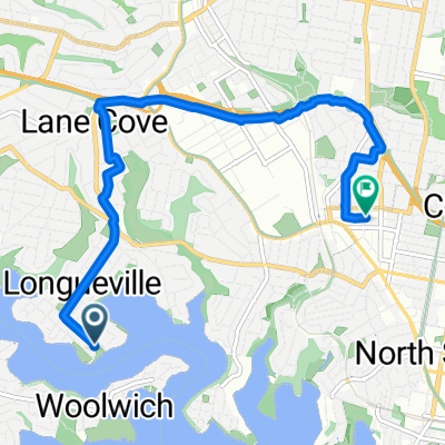
Lane Cove to 20 Charleroi Rd, Belrose
A cycling route starting in Longueville, New South Wales, Australia.
Overview
About this route
- 2 h 14 min
- Duration
- 18.5 km
- Distance
- 451 m
- Ascent
- 303 m
- Descent
- 8.3 km/h
- Avg. speed
- 179 m
- Max. altitude
Route quality
Waytypes & surfaces along the route
Waytypes
Quiet road
5.9 km
(32 %)
Cycleway
5.4 km
(29 %)
Surfaces
Paved
13.1 km
(71 %)
Concrete
5.9 km
(32 %)
Asphalt
5.2 km
(28 %)
Continue with Bikemap
Use, edit, or download this cycling route
You would like to ride Lane Cove to 20 Charleroi Rd, Belrose or customize it for your own trip? Here is what you can do with this Bikemap route:
Free features
- Save this route as favorite or in collections
- Copy & plan your own version of this route
- Sync your route with Garmin or Wahoo
Premium features
Free trial for 3 days, or one-time payment. More about Bikemap Premium.
- Navigate this route on iOS & Android
- Export a GPX / KML file of this route
- Create your custom printout (try it for free)
- Download this route for offline navigation
Discover more Premium features.
Get Bikemap PremiumFrom our community
Other popular routes starting in Longueville
 Lane Cove ride 1
- Distance
- 4.5 km
- Ascent
- 73 m
- Descent
- 60 m
- Location
- Longueville, New South Wales, Australia
 home to lunch in NS
- Distance
- 8.6 km
- Ascent
- 186 m
- Descent
- 163 m
- Location
- Longueville, New South Wales, Australia
 Mary Street 4, Longueville to Parriwi Road 83, Mosman
- Distance
- 13.3 km
- Ascent
- 198 m
- Descent
- 207 m
- Location
- Longueville, New South Wales, Australia
 Mary Street 2, Longueville to Parriwi Road 83, Mosman
- Distance
- 13.3 km
- Ascent
- 198 m
- Descent
- 207 m
- Location
- Longueville, New South Wales, Australia
 9 Campbell St, Hunters Hill to 7 Campbell St, Hunters Hill
- Distance
- 28.4 km
- Ascent
- 498 m
- Descent
- 496 m
- Location
- Longueville, New South Wales, Australia
 Recovered Route
- Distance
- 20.9 km
- Ascent
- 354 m
- Descent
- 366 m
- Location
- Longueville, New South Wales, Australia
 Kenneth Street, Longueville to 141 Longueville Road, Lane Cove
- Distance
- 0.9 km
- Ascent
- 24 m
- Descent
- 0 m
- Location
- Longueville, New South Wales, Australia
 Stuart St, Longueville to Willoughby Rd, Crows Nest
- Distance
- 7.9 km
- Ascent
- 190 m
- Descent
- 116 m
- Location
- Longueville, New South Wales, Australia
Open it in the app