

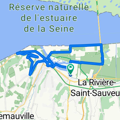
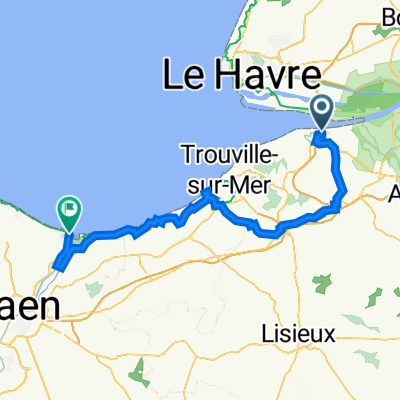
Honfleur Seine op en neer
A cycling route starting in La Rivière-Saint-Sauveur, Normandy, France.
Overview
About this route
- -:--
- Duration
- 383.2 km
- Distance
- 1,433 m
- Ascent
- 1,429 m
- Descent
- ---
- Avg. speed
- 122 m
- Max. altitude

Route highlights
Points of interest along the route
Point of interest after 59.2 km
Camping Des Forges
Point of interest after 88.2 km
Twee campings
Point of interest after 183.3 km
Camping les Terasses
Point of interest after 190 km
Camping
Point of interest after 193.5 km
Camping l'Ile Adeline
Point of interest after 196.1 km
Camping Lery-Poses
Point of interest after 217.7 km
Twee campings
Point of interest after 236.2 km
Camping?
Point of interest after 289.7 km
Blootcamping La Chènaie
Point of interest after 301.2 km
Camping
Point of interest after 304.8 km
Camping
Point of interest after 305.9 km
Camping
Point of interest after 307.3 km
Camping campspace
Point of interest after 345.4 km
Camping
Continue with Bikemap
Use, edit, or download this cycling route
You would like to ride Honfleur Seine op en neer or customize it for your own trip? Here is what you can do with this Bikemap route:
Free features
- Save this route as favorite or in collections
- Copy & plan your own version of this route
- Split it into stages to create a multi-day tour
- Sync your route with Garmin or Wahoo
Premium features
Free trial for 3 days, or one-time payment. More about Bikemap Premium.
- Navigate this route on iOS & Android
- Export a GPX / KML file of this route
- Create your custom printout (try it for free)
- Download this route for offline navigation
Discover more Premium features.
Get Bikemap PremiumFrom our community
Other popular routes starting in La Rivière-Saint-Sauveur
 Honfleur - Chatillon 213km
- Distance
- 212.9 km
- Ascent
- 504 m
- Descent
- 408 m
- Location
- La Rivière-Saint-Sauveur, Normandy, France
 normandie
- Distance
- 48.1 km
- Ascent
- 532 m
- Descent
- 536 m
- Location
- La Rivière-Saint-Sauveur, Normandy, France
 Honfleur 1 17.1
- Distance
- 16.8 km
- Ascent
- 205 m
- Descent
- 206 m
- Location
- La Rivière-Saint-Sauveur, Normandy, France
 Honfleur - Louviers 190 km
- Distance
- 181.6 km
- Ascent
- 639 m
- Descent
- 617 m
- Location
- La Rivière-Saint-Sauveur, Normandy, France
 Velofrancette 2023
- Distance
- 495.3 km
- Ascent
- 2,648 m
- Descent
- 2,613 m
- Location
- La Rivière-Saint-Sauveur, Normandy, France
 Le havre Ouistreham (après le pont de Normandie)
- Distance
- 80.8 km
- Ascent
- 576 m
- Descent
- 582 m
- Location
- La Rivière-Saint-Sauveur, Normandy, France
 Rue Saint Clair 823, La Rivière-Saint-Sauveur naar Vire
- Distance
- 136.1 km
- Ascent
- 1,512 m
- Descent
- 1,348 m
- Location
- La Rivière-Saint-Sauveur, Normandy, France
 Honfleur - Mons
- Distance
- 468.4 km
- Ascent
- 2,690 m
- Descent
- 2,653 m
- Location
- La Rivière-Saint-Sauveur, Normandy, France
Open it in the app