

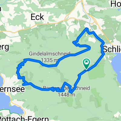
Schliersee nach Mühlthal, Valley
A cycling route starting in Schliersee, Bavaria, Germany.
Overview
About this route
- 1 h 5 min
- Duration
- 18.3 km
- Distance
- 314 m
- Ascent
- 491 m
- Descent
- 16.9 km/h
- Avg. speed
- 791 m
- Max. altitude

Route photos


Route quality
Waytypes & surfaces along the route
Waytypes
Quiet road
7.5 km
(41 %)
Track
6.2 km
(34 %)
Surfaces
Paved
12.4 km
(68 %)
Unpaved
4.9 km
(27 %)
Asphalt
11.9 km
(65 %)
Loose gravel
3.3 km
(18 %)
Continue with Bikemap
Use, edit, or download this cycling route
You would like to ride Schliersee nach Mühlthal, Valley or customize it for your own trip? Here is what you can do with this Bikemap route:
Free features
- Save this route as favorite or in collections
- Copy & plan your own version of this route
- Sync your route with Garmin or Wahoo
Premium features
Free trial for 3 days, or one-time payment. More about Bikemap Premium.
- Navigate this route on iOS & Android
- Export a GPX / KML file of this route
- Create your custom printout (try it for free)
- Download this route for offline navigation
Discover more Premium features.
Get Bikemap PremiumFrom our community
Other popular routes starting in Schliersee
 Let's kill the Hill
- Distance
- 136.6 km
- Ascent
- 1,317 m
- Descent
- 1,316 m
- Location
- Schliersee, Bavaria, Germany
 Hexal Alpen-Triathlon Radstrecke
- Distance
- 39.4 km
- Ascent
- 734 m
- Descent
- 526 m
- Location
- Schliersee, Bavaria, Germany
 Schliersee - Rohnberg - Neuhaus
- Distance
- 29.5 km
- Ascent
- 1,140 m
- Descent
- 1,144 m
- Location
- Schliersee, Bavaria, Germany
 Schliersee - Tegernsee
- Distance
- 23.2 km
- Ascent
- 925 m
- Descent
- 925 m
- Location
- Schliersee, Bavaria, Germany
 Schliersee nach Mühlthal, Valley
- Distance
- 18.3 km
- Ascent
- 314 m
- Descent
- 491 m
- Location
- Schliersee, Bavaria, Germany
 Valepprunde
- Distance
- 44.9 km
- Ascent
- 1,034 m
- Descent
- 1,031 m
- Location
- Schliersee, Bavaria, Germany
 Schliersee über Valepp zum Tegernsee und zurück
- Distance
- 28.6 km
- Ascent
- 591 m
- Descent
- 641 m
- Location
- Schliersee, Bavaria, Germany
 Dreiseenrunde Schliersee-Tegernsee-Spitzingsee
- Distance
- 52.3 km
- Ascent
- 771 m
- Descent
- 765 m
- Location
- Schliersee, Bavaria, Germany
Open it in the app