

Taubensuhl Bergzeitfahren
A cycling route starting in Eußerthal, Rhineland-Palatinate, Germany.
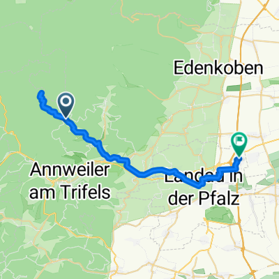
Overview
About this route
Eußerthal Ortsausgang - Schranke Taubensuhl
- -:--
- Duration
- 6.6 km
- Distance
- 439 m
- Ascent
- 130 m
- Descent
- ---
- Avg. speed
- 555 m
- Max. altitude

Route quality
Waytypes & surfaces along the route
Waytypes
Quiet road
6.4 km
(96 %)
Track
0.2 km
(4 %)
Undefined
-0 km
(<1 %)
Surfaces
Paved
6.4 km
(96 %)
Unpaved
0.2 km
(4 %)
Asphalt
6.4 km
(96 %)
Ground
0.2 km
(4 %)
Undefined
-0 km
(<1 %)
Continue with Bikemap
Use, edit, or download this cycling route
You would like to ride Taubensuhl Bergzeitfahren or customize it for your own trip? Here is what you can do with this Bikemap route:
Free features
- Save this route as favorite or in collections
- Copy & plan your own version of this route
- Sync your route with Garmin or Wahoo
Premium features
Free trial for 3 days, or one-time payment. More about Bikemap Premium.
- Navigate this route on iOS & Android
- Export a GPX / KML file of this route
- Create your custom printout (try it for free)
- Download this route for offline navigation
Discover more Premium features.
Get Bikemap PremiumFrom our community
Other popular routes starting in Eußerthal
 1Taubensuhl-JKreuz-Finsterbrunnertal-Z53
- Distance
- 25 km
- Ascent
- 181 m
- Descent
- 379 m
- Location
- Eußerthal, Rhineland-Palatinate, Germany
 Taubensuhl-Kalmit
- Distance
- 32.7 km
- Ascent
- 631 m
- Descent
- 998 m
- Location
- Eußerthal, Rhineland-Palatinate, Germany
 Rheinebenetour Eußerthal Wörth zurück über Hörth und Bellheim
- Distance
- 98 km
- Ascent
- 175 m
- Descent
- 168 m
- Location
- Eußerthal, Rhineland-Palatinate, Germany
 Taubensuhl Bergzeitfahren
- Distance
- 6.6 km
- Ascent
- 439 m
- Descent
- 130 m
- Location
- Eußerthal, Rhineland-Palatinate, Germany
 Taubensuhl 2, Landau in der Pfalz nach Ramburgstraße 1, Insheim
- Distance
- 27.7 km
- Ascent
- 232 m
- Descent
- 600 m
- Location
- Eußerthal, Rhineland-Palatinate, Germany
 Heldenstein, Taubensuhl, Helmbachweyher...Heldenstein
- Distance
- 27.2 km
- Ascent
- 452 m
- Descent
- 452 m
- Location
- Eußerthal, Rhineland-Palatinate, Germany
 Von Platz Nr. 5 in Eußerthal zum Platz Nr. 6 am Modenbacher Hof
- Distance
- 16.4 km
- Ascent
- 691 m
- Descent
- 609 m
- Location
- Eußerthal, Rhineland-Palatinate, Germany
 Aufnahme vom 03.07.2016, 14:57
- Distance
- 26.9 km
- Ascent
- 270 m
- Descent
- 327 m
- Location
- Eußerthal, Rhineland-Palatinate, Germany
Open it in the app