

route 14
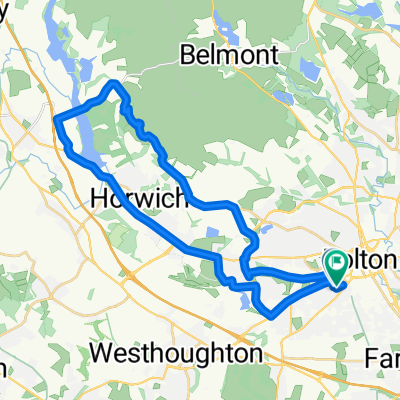
A cycling route starting in Bolton, England, United Kingdom.
Overview
About this route
Not many hills but a long way to go for an icecream...
- -:--
- Duration
- 142.8 km
- Distance
- 494 m
- Ascent
- 494 m
- Descent
- ---
- Avg. speed
- ---
- Max. altitude
Continue with Bikemap
Use, edit, or download this cycling route
You would like to ride route 14 or customize it for your own trip? Here is what you can do with this Bikemap route:
Free features
- Save this route as favorite or in collections
- Copy & plan your own version of this route
- Split it into stages to create a multi-day tour
- Sync your route with Garmin or Wahoo
Premium features
Free trial for 3 days, or one-time payment. More about Bikemap Premium.
- Navigate this route on iOS & Android
- Export a GPX / KML file of this route
- Create your custom printout (try it for free)
- Download this route for offline navigation
Discover more Premium features.
Get Bikemap PremiumFrom our community
Other popular routes starting in Bolton
 The Marklands, Bolton to Horrobin Lane, Chorley
- Distance
- 60 km
- Ascent
- 833 m
- Descent
- 865 m
- Location
- Bolton, England, United Kingdom
 Bolton - Salford Quays
- Distance
- 39.2 km
- Ascent
- 474 m
- Descent
- 475 m
- Location
- Bolton, England, United Kingdom
 route 14
- Distance
- 142.8 km
- Ascent
- 494 m
- Descent
- 494 m
- Location
- Bolton, England, United Kingdom
 belmont rivi
- Distance
- 39.7 km
- Ascent
- 507 m
- Descent
- 504 m
- Location
- Bolton, England, United Kingdom

Edge Explore 820®
Bolton Cycling- Distance
- 52.6 km
- Ascent
- 927 m
- Descent
- 934 m
- Location
- Bolton, England, United Kingdom
 Sandwick Crescent to Birkdale Gardens
- Distance
- 30.6 km
- Ascent
- 381 m
- Descent
- 431 m
- Location
- Bolton, England, United Kingdom
 Training Lopp Home
- Distance
- 64.6 km
- Ascent
- 578 m
- Descent
- 564 m
- Location
- Bolton, England, United Kingdom
 Bolton-Inverness?
- Distance
- 748.2 km
- Ascent
- 1,907 m
- Descent
- 2,116 m
- Location
- Bolton, England, United Kingdom
Open it in the app