

Le Tour De Friends 2022
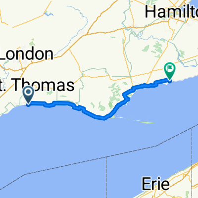
A cycling route starting in St. Thomas, Ontario, Canada.
Overview
About this route
Totalling 14km, Le Tour De Friends will tranverse the cityscape of St. Thomas once again, making stops at 7 different train stations along the way.
- -:--
- Duration
- 13.8 km
- Distance
- 47 m
- Ascent
- 49 m
- Descent
- ---
- Avg. speed
- 249 m
- Max. altitude

Route quality
Waytypes & surfaces along the route
Waytypes
Quiet road
9.2 km
(67 %)
Road
3.7 km
(27 %)
Surfaces
Paved
7.6 km
(55 %)
Asphalt
7.6 km
(55 %)
Paved (undefined)
0 km
(<1 %)
Undefined
6.2 km
(45 %)
Route highlights
Points of interest along the route
Point of interest after 2 km
Mexico on Myrtle 123 Myrtle Street
Point of interest after 3.2 km
Peg Leg Porkys 38 Park Ave
Point of interest after 3.7 km
Nancy Drew's 24 Cavanaugh Cres
Point of interest after 5.9 km
KFC 36 Coulter Ave
Point of interest after 8 km
Paul's Bike Shop 5 Lawrence Avenue
Point of interest after 11.4 km
The Garage 160 Fifth Ave
Continue with Bikemap
Use, edit, or download this cycling route
You would like to ride Le Tour De Friends 2022 or customize it for your own trip? Here is what you can do with this Bikemap route:
Free features
- Save this route as favorite or in collections
- Copy & plan your own version of this route
- Sync your route with Garmin or Wahoo
Premium features
Free trial for 3 days, or one-time payment. More about Bikemap Premium.
- Navigate this route on iOS & Android
- Export a GPX / KML file of this route
- Create your custom printout (try it for free)
- Download this route for offline navigation
Discover more Premium features.
Get Bikemap PremiumFrom our community
Other popular routes starting in St. Thomas
 Lake Erie Day 2 - Standley to Selkirk
- Distance
- 134.8 km
- Ascent
- 160 m
- Descent
- 151 m
- Location
- St. Thomas, Ontario, Canada
 Peach Tree Boulevard 242, St. Thomas to Peach Tree Boulevard 242, St. Thomas
- Distance
- 10.5 km
- Ascent
- 3 m
- Descent
- 9 m
- Location
- St. Thomas, Ontario, Canada
 Peach Tree Boulevard 242, St. Thomas to Peach Tree Boulevard 242, St. Thomas
- Distance
- 11.1 km
- Ascent
- 0 m
- Descent
- 7 m
- Location
- St. Thomas, Ontario, Canada
 Snail-like route in St Thomas
- Distance
- 9.4 km
- Ascent
- 126 m
- Descent
- 122 m
- Location
- St. Thomas, Ontario, Canada
 61 Bodkin St, Central Elgin to 56 Bodkin St, Central Elgin
- Distance
- 17.7 km
- Ascent
- 80 m
- Descent
- 79 m
- Location
- St. Thomas, Ontario, Canada
 244 Peach Tree Blvd, St. Thomas to 244 Peach Tree Blvd, St. Thomas
- Distance
- 4.5 km
- Ascent
- 3 m
- Descent
- 0 m
- Location
- St. Thomas, Ontario, Canada
 Relaxed route in St Thomas
- Distance
- 9.4 km
- Ascent
- 33 m
- Descent
- 12 m
- Location
- St. Thomas, Ontario, Canada
 Bike Hike Strike route 3
- Distance
- 6.1 km
- Ascent
- 79 m
- Descent
- 109 m
- Location
- St. Thomas, Ontario, Canada
Open it in the app