

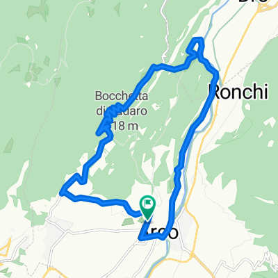
Via della Cinta 7, Arco do Via Lavino 14, Riva del Garda
A cycling route starting in Arco, Trentino-Alto Adige, Italy.
Overview
About this route
- 3 h 58 min
- Duration
- 44.9 km
- Distance
- 405 m
- Ascent
- 383 m
- Descent
- 11.3 km/h
- Avg. speed
- 282 m
- Max. altitude
Route quality
Waytypes & surfaces along the route
Waytypes
Cycleway
30.1 km
(67 %)
Quiet road
8.1 km
(18 %)
Surfaces
Paved
41.7 km
(93 %)
Asphalt
41.7 km
(93 %)
Undefined
3.1 km
(7 %)
Continue with Bikemap
Use, edit, or download this cycling route
You would like to ride Via della Cinta 7, Arco do Via Lavino 14, Riva del Garda or customize it for your own trip? Here is what you can do with this Bikemap route:
Free features
- Save this route as favorite or in collections
- Copy & plan your own version of this route
- Sync your route with Garmin or Wahoo
Premium features
Free trial for 3 days, or one-time payment. More about Bikemap Premium.
- Navigate this route on iOS & Android
- Export a GPX / KML file of this route
- Create your custom printout (try it for free)
- Download this route for offline navigation
Discover more Premium features.
Get Bikemap PremiumFrom our community
Other popular routes starting in Arco
 Arco.nach Malcesine Torbole Nago... Arco
- Distance
- 49.8 km
- Ascent
- 376 m
- Descent
- 420 m
- Location
- Arco, Trentino-Alto Adige, Italy
 Arco Tennosee
- Distance
- 60.9 km
- Ascent
- 1,004 m
- Descent
- 1,023 m
- Location
- Arco, Trentino-Alto Adige, Italy
 Monte Velo
- Distance
- 32.8 km
- Ascent
- 1,266 m
- Descent
- 1,266 m
- Location
- Arco, Trentino-Alto Adige, Italy
 Arco nach Tenno See
- Distance
- 27 km
- Ascent
- 619 m
- Descent
- 671 m
- Location
- Arco, Trentino-Alto Adige, Italy
 Arco über St. Giovanni zum Tennosee nach Arco
- Distance
- 40.7 km
- Ascent
- 1,304 m
- Descent
- 1,304 m
- Location
- Arco, Trentino-Alto Adige, Italy
 arco
arco- Distance
- 14.3 km
- Ascent
- 620 m
- Descent
- 620 m
- Location
- Arco, Trentino-Alto Adige, Italy
 Arco - Lago die Cavedine
- Distance
- 35.8 km
- Ascent
- 1,127 m
- Descent
- 1,063 m
- Location
- Arco, Trentino-Alto Adige, Italy
 Garda_Tour 1
- Distance
- 143.7 km
- Ascent
- 2,886 m
- Descent
- 2,883 m
- Location
- Arco, Trentino-Alto Adige, Italy
Open it in the app