

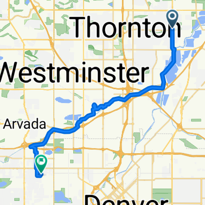
1882 E 104th Ave, Thornton a 1882 E 104th Ave, Thornton
A cycling route starting in Thornton, Colorado, United States.
Overview
About this route
- 1 h 3 min
- Duration
- 14.7 km
- Distance
- 168 m
- Ascent
- 173 m
- Descent
- 14.1 km/h
- Avg. speed
- 1,636 m
- Max. altitude

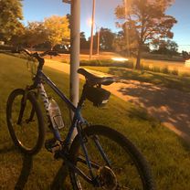
Route photos


Route quality
Waytypes & surfaces along the route
Waytypes
Cycleway
8.8 km
(60 %)
Access road
1.8 km
(12 %)
Surfaces
Paved
10.3 km
(70 %)
Unpaved
0.7 km
(5 %)
Paved (undefined)
6.6 km
(45 %)
Concrete
3.2 km
(22 %)
Continue with Bikemap
Use, edit, or download this cycling route
You would like to ride 1882 E 104th Ave, Thornton a 1882 E 104th Ave, Thornton or customize it for your own trip? Here is what you can do with this Bikemap route:
Free features
- Save this route as favorite or in collections
- Copy & plan your own version of this route
- Sync your route with Garmin or Wahoo
Premium features
Free trial for 3 days, or one-time payment. More about Bikemap Premium.
- Navigate this route on iOS & Android
- Export a GPX / KML file of this route
- Create your custom printout (try it for free)
- Download this route for offline navigation
Discover more Premium features.
Get Bikemap PremiumFrom our community
Other popular routes starting in Thornton
 Colorado Blvd, Thornton to 3363 Jay St, Wheat Ridge
- Distance
- 23.9 km
- Ascent
- 144 m
- Descent
- 51 m
- Location
- Thornton, Colorado, United States
 1882 E 104th Ave, Thornton a 1882 E 104th Ave, Thornton
- Distance
- 14.7 km
- Ascent
- 168 m
- Descent
- 173 m
- Location
- Thornton, Colorado, United States
 8801–8825 Pearl St, Thornton to 9170 N Newton St, Westminster
- Distance
- 71.1 km
- Ascent
- 514 m
- Descent
- 446 m
- Location
- Thornton, Colorado, United States
 De East 104th Avenue 1882, Northglenn a East 104th Avenue 1882, Northglenn
- Distance
- 0 km
- Ascent
- 0 m
- Descent
- 0 m
- Location
- Thornton, Colorado, United States
 1882 E 104th Ave, Thornton a 1882 E 104th Ave, Thornton
- Distance
- 10.2 km
- Ascent
- 99 m
- Descent
- 98 m
- Location
- Thornton, Colorado, United States
 1882 E 104th Ave, Thornton a 1882 E 104th Ave, Thornton
- Distance
- 4.7 km
- Ascent
- 30 m
- Descent
- 35 m
- Location
- Thornton, Colorado, United States
 10466 Madison Way, Northglenn to 4750–4798 E 25th Ave, Denver
- Distance
- 18 km
- Ascent
- 126 m
- Descent
- 94 m
- Location
- Thornton, Colorado, United States
 from colo
- Distance
- 8 km
- Ascent
- 84 m
- Descent
- 4 m
- Location
- Thornton, Colorado, United States
Open it in the app