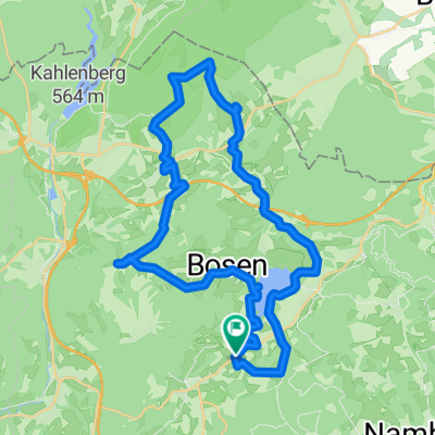
WND Land (Marpingen included)
A cycling route starting in Oberthal, Saarland, Germany.
Overview
About this route
Start in Güdesweiler - Grünschnittanlage - Tholey - Marpingen - [Am Biehl - Saar-Oster-Höhen-Radweg in Richtung Rheinstrasse - in Richtung Habenichts - WND-Land MTB5 - zurück bis Haydnstrasse] - wieder auf WND-Land MTB5 - Schloßstraße Urexweiler - Habenichts - Remmesweiler - Oberlinxweiler - WND - Wallesweilerhof - Bliesen-Gombacher Mühle - WND-Land MTB3 - zurück nach Güdesweiler
- -:--
- Duration
- 46.8 km
- Distance
- 804 m
- Ascent
- 804 m
- Descent
- ---
- Avg. speed
- 425 m
- Avg. speed
Route quality
Waytypes & surfaces along the route
Waytypes
Track
18 km
(38 %)
Quiet road
15.3 km
(33 %)
Surfaces
Paved
34.6 km
(74 %)
Unpaved
6.4 km
(14 %)
Asphalt
25.6 km
(55 %)
Paved (undefined)
8.1 km
(17 %)
Continue with Bikemap
Use, edit, or download this cycling route
You would like to ride WND Land (Marpingen included) or customize it for your own trip? Here is what you can do with this Bikemap route:
Free features
- Save this route as favorite or in collections
- Copy & plan your own version of this route
- Sync your route with Garmin or Wahoo
Premium features
Free trial for 3 days, or one-time payment. More about Bikemap Premium.
- Navigate this route on iOS & Android
- Export a GPX / KML file of this route
- Create your custom printout (try it for free)
- Download this route for offline navigation
Discover more Premium features.
Get Bikemap PremiumFrom our community
Other popular routes starting in Oberthal
- Güdesweiler - Bliesen - Baltersweiler
- Distance
- 15.3 km
- Ascent
- 214 m
- Descent
- 216 m
- Location
- Oberthal, Saarland, Germany
- Nahe-Radweg
- Distance
- 133.7 km
- Ascent
- 1,818 m
- Descent
- 2,198 m
- Location
- Oberthal, Saarland, Germany
- Schaumbergtrails mit Hofgut Imsbach
- Distance
- 43.8 km
- Ascent
- 849 m
- Descent
- 849 m
- Location
- Oberthal, Saarland, Germany
- Ob-N-Nahe-Eiw-Peterberg
- Distance
- 13.3 km
- Ascent
- 418 m
- Descent
- 136 m
- Location
- Oberthal, Saarland, Germany
- 20141026_100525
- Distance
- 36 km
- Ascent
- 427 m
- Descent
- 424 m
- Location
- Oberthal, Saarland, Germany
- Güdesweiler-Baltersweiler-Wallesweilerhof-Winterbach-Rheinstrasse-Habenichts-Remmesweiler-Oberlinxweiler-WND-Wackenbornermühle
- Distance
- 36.3 km
- Ascent
- 563 m
- Descent
- 563 m
- Location
- Oberthal, Saarland, Germany
- Güdesw.-Buchwald-Bost.See-
- Distance
- 28.2 km
- Ascent
- 336 m
- Descent
- 342 m
- Location
- Oberthal, Saarland, Germany
- WND Land (Marpingen included)
- Distance
- 46.8 km
- Ascent
- 804 m
- Descent
- 804 m
- Location
- Oberthal, Saarland, Germany
Open it in the app