

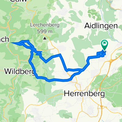
Thomas-Mann-Straße 21, Gärtringen nach Thomas-Mann-Straße 14, Gärtringen
A cycling route starting in Gärtringen, Baden-Wurttemberg, Germany.
Overview
About this route
- 1 h 36 min
- Duration
- 13.5 km
- Distance
- 90 m
- Ascent
- 95 m
- Descent
- 8.4 km/h
- Avg. speed
- 491 m
- Max. altitude

Route quality
Waytypes & surfaces along the route
Waytypes
Track
9.1 km
(67 %)
Cycleway
2 km
(15 %)
Surfaces
Paved
13.5 km
(100 %)
Asphalt
13.5 km
(100 %)
Continue with Bikemap
Use, edit, or download this cycling route
You would like to ride Thomas-Mann-Straße 21, Gärtringen nach Thomas-Mann-Straße 14, Gärtringen or customize it for your own trip? Here is what you can do with this Bikemap route:
Free features
- Save this route as favorite or in collections
- Copy & plan your own version of this route
- Sync your route with Garmin or Wahoo
Premium features
Free trial for 3 days, or one-time payment. More about Bikemap Premium.
- Navigate this route on iOS & Android
- Export a GPX / KML file of this route
- Create your custom printout (try it for free)
- Download this route for offline navigation
Discover more Premium features.
Get Bikemap PremiumFrom our community
Other popular routes starting in Gärtringen
 Test
Test- Distance
- 20.7 km
- Ascent
- 156 m
- Descent
- 156 m
- Location
- Gärtringen, Baden-Wurttemberg, Germany
 Gärtringen - Sulz am Eck - Altdorf
- Distance
- 56.9 km
- Ascent
- 650 m
- Descent
- 668 m
- Location
- Gärtringen, Baden-Wurttemberg, Germany
 Gäurandtour
- Distance
- 67.4 km
- Ascent
- 451 m
- Descent
- 451 m
- Location
- Gärtringen, Baden-Wurttemberg, Germany
 32km
32km- Distance
- 32.6 km
- Ascent
- 172 m
- Descent
- 171 m
- Location
- Gärtringen, Baden-Wurttemberg, Germany
 Kevin, Wiesengarten, Katze
- Distance
- 21.1 km
- Ascent
- 202 m
- Descent
- 217 m
- Location
- Gärtringen, Baden-Wurttemberg, Germany
 Gärtringen, Aidlingen, Dachtel
- Distance
- 16.2 km
- Ascent
- 406 m
- Descent
- 364 m
- Location
- Gärtringen, Baden-Wurttemberg, Germany
 Gärtringen Krabbanescht in Holzbronn
- Distance
- 36.6 km
- Ascent
- 424 m
- Descent
- 422 m
- Location
- Gärtringen, Baden-Wurttemberg, Germany
 Renningen Wenninger Höfe 45 KM
- Distance
- 44.6 km
- Ascent
- 284 m
- Descent
- 284 m
- Location
- Gärtringen, Baden-Wurttemberg, Germany
Open it in the app