

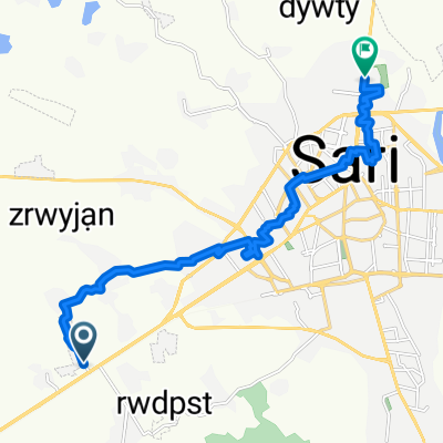
36.557° N 53.073° W to 36.538° N 53.069° W
A cycling route starting in Sari, Mazandaran, Iran.
Overview
About this route
- 15 min
- Duration
- 3.6 km
- Distance
- 53 m
- Ascent
- 47 m
- Descent
- 14.2 km/h
- Avg. speed
- 60 m
- Max. altitude
Continue with Bikemap
Use, edit, or download this cycling route
You would like to ride 36.557° N 53.073° W to 36.538° N 53.069° W or customize it for your own trip? Here is what you can do with this Bikemap route:
Free features
- Save this route as favorite or in collections
- Copy & plan your own version of this route
- Sync your route with Garmin or Wahoo
Premium features
Free trial for 3 days, or one-time payment. More about Bikemap Premium.
- Navigate this route on iOS & Android
- Export a GPX / KML file of this route
- Create your custom printout (try it for free)
- Download this route for offline navigation
Discover more Premium features.
Get Bikemap PremiumFrom our community
Other popular routes starting in Sari
 بوستان
- Distance
- 15.5 km
- Ascent
- 31 m
- Descent
- 26 m
- Location
- Sari, Mazandaran, Iran
 , ساری to M29P+789, سنته
- Distance
- 15.1 km
- Ascent
- 4 m
- Descent
- 50 m
- Location
- Sari, Mazandaran, Iran
 Steady ride
- Distance
- 11.1 km
- Ascent
- 203 m
- Descent
- 186 m
- Location
- Sari, Mazandaran, Iran
 Steady ride in
- Distance
- 26 km
- Ascent
- 321 m
- Descent
- 318 m
- Location
- Sari, Mazandaran, Iran
 Relaxed route
- Distance
- 10.5 km
- Ascent
- 172 m
- Descent
- 156 m
- Location
- Sari, Mazandaran, Iran
 Steady ride
- Distance
- 9.6 km
- Ascent
- 207 m
- Descent
- 216 m
- Location
- Sari, Mazandaran, Iran
 210202
- Distance
- 10 km
- Ascent
- 94 m
- Descent
- 104 m
- Location
- Sari, Mazandaran, Iran
 Keshavarz Boulevard, Sari to Sari
- Distance
- 5.4 km
- Ascent
- 19 m
- Descent
- 34 m
- Location
- Sari, Mazandaran, Iran
Open it in the app