

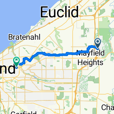
North Chagrin Reservation
A cycling route starting in Mayfield, Ohio, United States.
Overview
About this route
- -:--
- Duration
- 25.6 km
- Distance
- 187 m
- Ascent
- 177 m
- Descent
- ---
- Avg. speed
- ---
- Max. altitude
Route quality
Waytypes & surfaces along the route
Waytypes
Pedestrian area
6.7 km
(26 %)
Road
6.1 km
(24 %)
Surfaces
Paved
15.2 km
(59 %)
Unpaved
3.6 km
(14 %)
Asphalt
15.2 km
(59 %)
Ground
2.6 km
(10 %)
Continue with Bikemap
Use, edit, or download this cycling route
You would like to ride North Chagrin Reservation or customize it for your own trip? Here is what you can do with this Bikemap route:
Free features
- Save this route as favorite or in collections
- Copy & plan your own version of this route
- Sync your route with Garmin or Wahoo
Premium features
Free trial for 3 days, or one-time payment. More about Bikemap Premium.
- Navigate this route on iOS & Android
- Export a GPX / KML file of this route
- Create your custom printout (try it for free)
- Download this route for offline navigation
Discover more Premium features.
Get Bikemap PremiumFrom our community
Other popular routes starting in Mayfield
 736 Som Center Rd, Mayfield to 6592 Som Ct, Mayfield
- Distance
- 7.4 km
- Ascent
- 27 m
- Descent
- 29 m
- Location
- Mayfield, Ohio, United States
 North Chagrin Reservation
- Distance
- 25.6 km
- Ascent
- 187 m
- Descent
- 177 m
- Location
- Mayfield, Ohio, United States
 5-9-15
- Distance
- 11.6 km
- Ascent
- 85 m
- Descent
- 97 m
- Location
- Mayfield, Ohio, United States
 309 Som Center Rd, Mayfield to 25635 Chardon Rd, Richmond Heights
- Distance
- 7 km
- Ascent
- 33 m
- Descent
- 39 m
- Location
- Mayfield, Ohio, United States
 789 Som Center Rd, Mayfield to 309 Som Center Rd, Mayfield
- Distance
- 3.7 km
- Ascent
- 7 m
- Descent
- 26 m
- Location
- Mayfield, Ohio, United States
 309 Som Center Rd, Mayfield to 968 W Mill Dr, Highland Heights
- Distance
- 10.6 km
- Ascent
- 105 m
- Descent
- 68 m
- Location
- Mayfield, Ohio, United States
 Aintree Park Dr, Mayfield to E 93rd St, Cleveland
- Distance
- 21.3 km
- Ascent
- 68 m
- Descent
- 174 m
- Location
- Mayfield, Ohio, United States
 309 Som Center Rd, Mayfield to Buttermilk Falls Pkwy, Mayfield
- Distance
- 12.4 km
- Ascent
- 100 m
- Descent
- 106 m
- Location
- Mayfield, Ohio, United States
Open it in the app