

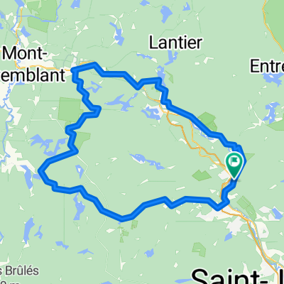
1-Les Laurentides 2022
A cycling route starting in Sainte-Adèle, Quebec, Canada.
Overview
About this route
- -:--
- Duration
- 80 km
- Distance
- 1,093 m
- Ascent
- 1,182 m
- Descent
- ---
- Avg. speed
- 426 m
- Max. altitude

Route quality
Waytypes & surfaces along the route
Waytypes
Road
39.2 km
(49 %)
Cycleway
20 km
(25 %)
Surfaces
Paved
41.6 km
(52 %)
Unpaved
35.2 km
(44 %)
Asphalt
30.4 km
(38 %)
Loose gravel
19.2 km
(24 %)
Route highlights
Points of interest along the route
Point of interest after 60.2 km
camping les etangs... 819 210 1099 48 chemin de la montagne...
Point of interest after 67.1 km
Camping l escapade 819 210 1099 48 chemin de la montagne
Point of interest after 80 km
camping Domaine des cedres 819 425 3950 60 chemin du domaine
Point of interest after 80 km
Camping de la montgne d argent 1321 rue de la montagne 819 686 5207
Continue with Bikemap
Use, edit, or download this cycling route
You would like to ride 1-Les Laurentides 2022 or customize it for your own trip? Here is what you can do with this Bikemap route:
Free features
- Save this route as favorite or in collections
- Copy & plan your own version of this route
- Split it into stages to create a multi-day tour
- Sync your route with Garmin or Wahoo
Premium features
Free trial for 3 days, or one-time payment. More about Bikemap Premium.
- Navigate this route on iOS & Android
- Export a GPX / KML file of this route
- Create your custom printout (try it for free)
- Download this route for offline navigation
Discover more Premium features.
Get Bikemap PremiumFrom our community
Other popular routes starting in Sainte-Adèle
 GARENUT120ISH2018
- Distance
- 127 km
- Ascent
- 717 m
- Descent
- 717 m
- Location
- Sainte-Adèle, Quebec, Canada
 SteMarguerite to SteAgathe
- Distance
- 16 km
- Ascent
- 152 m
- Descent
- 60 m
- Location
- Sainte-Adèle, Quebec, Canada
 Estelle Lantier
- Distance
- 93.4 km
- Ascent
- 496 m
- Descent
- 494 m
- Location
- Sainte-Adèle, Quebec, Canada
 Legendary Spill
- Distance
- 52.3 km
- Ascent
- 500 m
- Descent
- 506 m
- Location
- Sainte-Adèle, Quebec, Canada
 ste adele bellefeuille ste adele
- Distance
- 66.6 km
- Ascent
- 908 m
- Descent
- 905 m
- Location
- Sainte-Adèle, Quebec, Canada
 Ste adele lac louisa
- Distance
- 75.1 km
- Ascent
- 1,060 m
- Descent
- 1,038 m
- Location
- Sainte-Adèle, Quebec, Canada
 ste adele
- Distance
- 46.1 km
- Ascent
- 626 m
- Descent
- 674 m
- Location
- Sainte-Adèle, Quebec, Canada
 Route 370 (Sainte-Adèle) à Mont-Tremblant
- Distance
- 49.9 km
- Ascent
- 213 m
- Descent
- 271 m
- Location
- Sainte-Adèle, Quebec, Canada
Open it in the app