

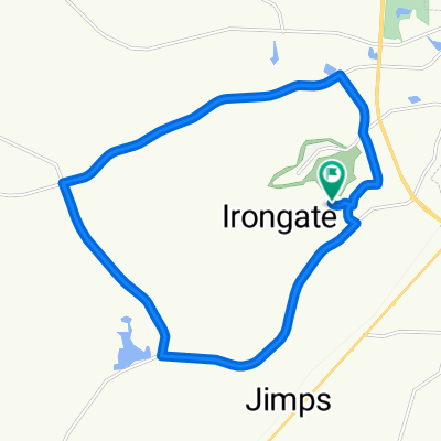
591 Gentilly Rd, Statesboro to 133 Lanier Dr, Statesboro
A cycling route starting in Statesboro, Georgia, United States.
Overview
About this route
- 1 h 35 min
- Duration
- 35.9 km
- Distance
- 153 m
- Ascent
- 149 m
- Descent
- 22.6 km/h
- Avg. speed
- 74 m
- Max. altitude

Route quality
Waytypes & surfaces along the route
Waytypes
Cycleway
15.7 km
(44 %)
Quiet road
14.4 km
(40 %)
Surfaces
Paved
21.1 km
(59 %)
Paved (undefined)
12.2 km
(34 %)
Asphalt
8.9 km
(25 %)
Undefined
14.8 km
(41 %)
Continue with Bikemap
Use, edit, or download this cycling route
You would like to ride 591 Gentilly Rd, Statesboro to 133 Lanier Dr, Statesboro or customize it for your own trip? Here is what you can do with this Bikemap route:
Free features
- Save this route as favorite or in collections
- Copy & plan your own version of this route
- Sync your route with Garmin or Wahoo
Premium features
Free trial for 3 days, or one-time payment. More about Bikemap Premium.
- Navigate this route on iOS & Android
- Export a GPX / KML file of this route
- Create your custom printout (try it for free)
- Download this route for offline navigation
Discover more Premium features.
Get Bikemap PremiumFrom our community
Other popular routes starting in Statesboro
 1818 Chandler Rd, Statesboro to 7 E Kennedy St, Statesboro
- Distance
- 4.2 km
- Ascent
- 46 m
- Descent
- 46 m
- Location
- Statesboro, Georgia, United States
 207 S Edgewood Dr, Statesboro to 107 W Main St, Statesboro
- Distance
- 14.8 km
- Ascent
- 63 m
- Descent
- 54 m
- Location
- Statesboro, Georgia, United States
 134 Hazelwood Dr, Statesboro to 134 Hazelwood Dr, Statesboro
- Distance
- 19.9 km
- Ascent
- 131 m
- Descent
- 132 m
- Location
- Statesboro, Georgia, United States
 1818 Chandler Rd, Statesboro to 1818 Chandler Rd, Statesboro
- Distance
- 7.8 km
- Ascent
- 48 m
- Descent
- 51 m
- Location
- Statesboro, Georgia, United States
 US-301, Statesboro to 7 College Plaza, Statesboro
- Distance
- 6.6 km
- Ascent
- 35 m
- Descent
- 35 m
- Location
- Statesboro, Georgia, United States
 591 Gentilly Rd, Statesboro to 133 Lanier Dr, Statesboro
- Distance
- 35.9 km
- Ascent
- 153 m
- Descent
- 149 m
- Location
- Statesboro, Georgia, United States
 100 Bermuda Run, Statesboro to 1 S College St, Statesboro
- Distance
- 4.4 km
- Ascent
- 39 m
- Descent
- 34 m
- Location
- Statesboro, Georgia, United States
 1400 Southern Dr, Statesboro to 984 Plant Dr, Statesboro
- Distance
- 1.2 km
- Ascent
- 20 m
- Descent
- 19 m
- Location
- Statesboro, Georgia, United States
Open it in the app