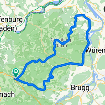
1. Etappe Frick - Lenzkirch
A cycling route starting in Frick, Canton of Aargau, Switzerland.
Overview
About this route
Frick - Laufenburg - Hochsal - Albtal - Sankt Blasien - Menzenschwand- Schluchsee - Bonndorf - Lenzkirch
- -:--
- Duration
- 87.4 km
- Distance
- 1,244 m
- Ascent
- 747 m
- Descent
- ---
- Avg. speed
- ---
- Max. altitude
Route quality
Waytypes & surfaces along the route
Waytypes
Road
14.9 km
(17 %)
Track
12.2 km
(14 %)
Surfaces
Paved
63.8 km
(73 %)
Unpaved
13.1 km
(15 %)
Asphalt
62 km
(71 %)
Gravel
8.7 km
(10 %)
Continue with Bikemap
Use, edit, or download this cycling route
You would like to ride 1. Etappe Frick - Lenzkirch or customize it for your own trip? Here is what you can do with this Bikemap route:
Free features
- Save this route as favorite or in collections
- Copy & plan your own version of this route
- Split it into stages to create a multi-day tour
- Sync your route with Garmin or Wahoo
Premium features
Free trial for 3 days, or one-time payment. More about Bikemap Premium.
- Navigate this route on iOS & Android
- Export a GPX / KML file of this route
- Create your custom printout (try it for free)
- Download this route for offline navigation
Discover more Premium features.
Get Bikemap PremiumFrom our community
Other popular routes starting in Frick
MTB Hornussen 2013 60 km- Distance
- 56.9 km
- Ascent
- 1,372 m
- Descent
- 1,372 m
- Location
- Frick, Canton of Aargau, Switzerland
MTB Hornussen 2014 60km- Distance
- 56.2 km
- Ascent
- 1,101 m
- Descent
- 1,101 m
- Location
- Frick, Canton of Aargau, Switzerland
Recovered Route- Distance
- 52.3 km
- Ascent
- 396 m
- Descent
- 462 m
- Location
- Frick, Canton of Aargau, Switzerland
Frick Kaisten Eiken- Distance
- 16.2 km
- Ascent
- 208 m
- Descent
- 206 m
- Location
- Frick, Canton of Aargau, Switzerland
1. Etappe Frick - Lenzkirch- Distance
- 87.4 km
- Ascent
- 1,244 m
- Descent
- 747 m
- Location
- Frick, Canton of Aargau, Switzerland
Fricktaler Huegelvergnuege Abendtraining- Distance
- 27.8 km
- Ascent
- 406 m
- Descent
- 345 m
- Location
- Frick, Canton of Aargau, Switzerland
Hauptstrasse, Bözen nach Kirchweg, Bözen- Distance
- 13.1 km
- Ascent
- 92 m
- Descent
- 80 m
- Location
- Frick, Canton of Aargau, Switzerland
Bözen-Bözberg-Leuggern-Hottwil-Mönthal-Bözen- Distance
- 43.3 km
- Ascent
- 634 m
- Descent
- 621 m
- Location
- Frick, Canton of Aargau, Switzerland
Open it in the app


