20170326_140233.gpx
- 31 km
- 260 m
- 260 m
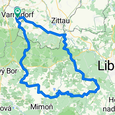
- Varnsdorf, Ústecký kraj, Czechia
A cycling route starting in Varnsdorf, Ústecký kraj, Czechia.
Overview
This time not through the Neisse Valley, but past Grabstein Castle towards Chrastava, continuing on cycle path No. 14 always on the outskirts of Liberec at 'half height' to the foot of Jeschken and all the way up to enjoy the view... Afterwards, a western descent and south around the Jeschken mountain range (partly on luxurious asphalt with great views!) first back up to 610m, then down to the Neisse and in Jablonec into the Giant Mountains through all of Pedrichov with a break at the well-stocked kiosk at the upper large parking lot. Continue to the Iser-Riesengebirgs Magistral (cycle path 22) and down this way to Mnisek (first slow-speed asphalt, then to balance a nice separate cycle path). From here another little detour back into the mountains (very steep, on rather poor asphalt, but still suitable for racing bikes), in the side valley of the Black Neisse back to Liberec and from there along the Lusatian Neisse back to Harthau, not without a short intensive recovery at the beach bar in Hradek.
created this 14 years ago
Route quality
Road
83 km
(58 %)
Quiet road
25.8 km
(18 %)
Paved
105.9 km
(74 %)
Unpaved
4.3 km
(3 %)
Asphalt
105.9 km
(74 %)
Unpaved (undefined)
2.9 km
(2 %)
Route highlights


Continue with Bikemap
You would like to ride 2011-07-16 Harthau-Jeschken-Südumfahrung-Bedrichov-Isergebirge or customize it for your own trip? Here is what you can do with this Bikemap route:
Free trial for 3 days, or one-time payment. More about Bikemap Premium.
Discover more Premium features.
Get Bikemap PremiumFrom our community
Open it in the app