

Ze Sterzingu do Nauders-San Benedetto
A cycling route starting in Sterzing, Trentino-Alto Adige, Italy.
Overview
About this route
Trasa zpočátku rovinatá mimo stoupání v poslední třetině.Vede převážně po cyklostezkách,zčásti po silnicích s minimálním provozem.
- -:--
- Duration
- 36.9 km
- Distance
- 463 m
- Ascent
- 423 m
- Descent
- ---
- Avg. speed
- ---
- Max. altitude
Route quality
Waytypes & surfaces along the route
Waytypes
Quiet road
8.1 km
(22 %)
Track
7 km
(19 %)
Surfaces
Paved
28.4 km
(77 %)
Unpaved
1.1 km
(3 %)
Asphalt
28.4 km
(77 %)
Unpaved (undefined)
0.7 km
(2 %)
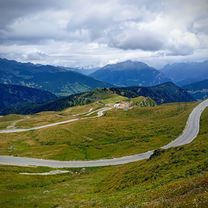
Route highlights
Points of interest along the route

Photo after 0.8 km
Sterzing

Photo after 6.9 km
Stilves-kostel

Photo after 24.5 km
Franzenfeste

Photo after 25.6 km
výhled s mostu pod přehradou

Photo after 26.3 km
Aica

Photo after 27.5 km
Aica.most přes Isarco

Photo after 30.1 km
cestou do Mühlbach

Photo after 30.9 km
v údolí Mühbach

Photo after 31.8 km
Mühlbach

Photo after 32.6 km
Mühlbach-náměstí

Photo after 34.6 km
Mühlbach

Photo after 36.6 km
výhled z Nauders-San Benedetto
Continue with Bikemap
Use, edit, or download this cycling route
You would like to ride Ze Sterzingu do Nauders-San Benedetto or customize it for your own trip? Here is what you can do with this Bikemap route:
Free features
- Save this route as favorite or in collections
- Copy & plan your own version of this route
- Sync your route with Garmin or Wahoo
Premium features
Free trial for 3 days, or one-time payment. More about Bikemap Premium.
- Navigate this route on iOS & Android
- Export a GPX / KML file of this route
- Create your custom printout (try it for free)
- Download this route for offline navigation
Discover more Premium features.
Get Bikemap PremiumFrom our community
Other popular routes starting in Sterzing
 24.6. Vipiteno - Toblach
- Distance
- 86.1 km
- Ascent
- 2,166 m
- Descent
- 1,901 m
- Location
- Sterzing, Trentino-Alto Adige, Italy
 lidl-tour-2015-1-1
- Distance
- 139.6 km
- Ascent
- 1,361 m
- Descent
- 1,632 m
- Location
- Sterzing, Trentino-Alto Adige, Italy
 Singlikate Via Alpia 2015 VIII etapp 127 km
- Distance
- 127.3 km
- Ascent
- 1,763 m
- Descent
- 2,487 m
- Location
- Sterzing, Trentino-Alto Adige, Italy
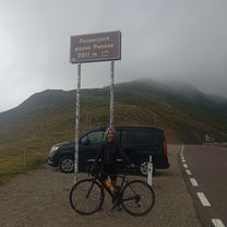 PASSO DI PENNES/ PENSERJONCH (por Vipiteno/ Sterzing)
- Distance
- 16.6 km
- Ascent
- 1,630 m
- Descent
- 384 m
- Location
- Sterzing, Trentino-Alto Adige, Italy
 PASSO DI MONTE GIOVO/ JAUFENPASS (por Gasteig/ Casateia)
- Distance
- 17.3 km
- Ascent
- 1,282 m
- Descent
- 137 m
- Location
- Sterzing, Trentino-Alto Adige, Italy
 Südtirol 2019
- Distance
- 472.6 km
- Ascent
- 2,857 m
- Descent
- 2,857 m
- Location
- Sterzing, Trentino-Alto Adige, Italy
 Vipiteno - Seefeld
- Distance
- 64.4 km
- Ascent
- 1,513 m
- Descent
- 1,884 m
- Location
- Sterzing, Trentino-Alto Adige, Italy
 1. etappe, 10. mai, Sterzing til Brunico
- Distance
- 56.2 km
- Ascent
- 1,454 m
- Descent
- 1,564 m
- Location
- Sterzing, Trentino-Alto Adige, Italy
Open it in the app