

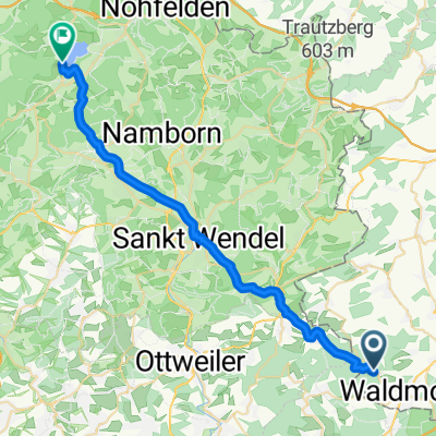
Am Südhang 7, Dunzweiler nach Seitersstraße 32, Herschweiler-Pettersheim
A cycling route starting in Dunzweiler, Rhineland-Palatinate, Germany.
Overview
About this route
- 43 min
- Duration
- 10.7 km
- Distance
- 125 m
- Ascent
- 203 m
- Descent
- 15 km/h
- Avg. speed
- 366 m
- Max. altitude
Route quality
Waytypes & surfaces along the route
Waytypes
Busy road
3.8 km
(35 %)
Quiet road
2.9 km
(28 %)
Surfaces
Paved
10.6 km
(99 %)
Asphalt
7.7 km
(73 %)
Paved (undefined)
2.9 km
(27 %)
Undefined
0.1 km
(<1 %)
Continue with Bikemap
Use, edit, or download this cycling route
You would like to ride Am Südhang 7, Dunzweiler nach Seitersstraße 32, Herschweiler-Pettersheim or customize it for your own trip? Here is what you can do with this Bikemap route:
Free features
- Save this route as favorite or in collections
- Copy & plan your own version of this route
- Sync your route with Garmin or Wahoo
Premium features
Free trial for 3 days, or one-time payment. More about Bikemap Premium.
- Navigate this route on iOS & Android
- Export a GPX / KML file of this route
- Create your custom printout (try it for free)
- Download this route for offline navigation
Discover more Premium features.
Get Bikemap PremiumFrom our community
Other popular routes starting in Dunzweiler
 mittlere w-z-hüttenrunde
- Distance
- 40.6 km
- Ascent
- 601 m
- Descent
- 551 m
- Location
- Dunzweiler, Rhineland-Palatinate, Germany
 Brunnenstraße 10, Bexbach nach Sankt Wendeler Straße 1–3, Pfeffelbach
- Distance
- 26.1 km
- Ascent
- 386 m
- Descent
- 493 m
- Location
- Dunzweiler, Rhineland-Palatinate, Germany
 waldziegelhütte
- Distance
- 31.5 km
- Ascent
- 556 m
- Descent
- 518 m
- Location
- Dunzweiler, Rhineland-Palatinate, Germany
 Höcherbergstraße, Schönenberg-Kübelberg nach Erbbiegel, St. Wendel
- Distance
- 17 km
- Ascent
- 359 m
- Descent
- 391 m
- Location
- Dunzweiler, Rhineland-Palatinate, Germany
 Saarland Rundwanderweg, Ottweiler nach Homburg
- Distance
- 5.6 km
- Ascent
- 28 m
- Descent
- 252 m
- Location
- Dunzweiler, Rhineland-Palatinate, Germany
 um lautenbach
- Distance
- 22.2 km
- Ascent
- 486 m
- Descent
- 480 m
- Location
- Dunzweiler, Rhineland-Palatinate, Germany
 wendelinushof
- Distance
- 29.2 km
- Ascent
- 533 m
- Descent
- 455 m
- Location
- Dunzweiler, Rhineland-Palatinate, Germany
 mittlere w-z-hüttenrunde CLONED FROM ROUTE 37341
- Distance
- 40.7 km
- Ascent
- 551 m
- Descent
- 551 m
- Location
- Dunzweiler, Rhineland-Palatinate, Germany
Open it in the app