

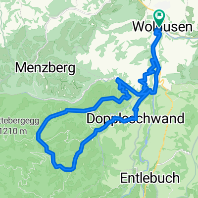
De Menznauerstrasse 49, Wolhusen a Menznauerstrasse 49, Wolhusen
A cycling route starting in Wolhusen, Canton of Lucerne, Switzerland.
Overview
About this route
- 1 h 52 min
- Duration
- 33.3 km
- Distance
- 155 m
- Ascent
- 161 m
- Descent
- 17.8 km/h
- Avg. speed
- 592 m
- Max. altitude

Route quality
Waytypes & surfaces along the route
Waytypes
Path
13.7 km
(41 %)
Track
7 km
(21 %)
Surfaces
Paved
10.7 km
(32 %)
Unpaved
8.7 km
(26 %)
Asphalt
10.3 km
(31 %)
Gravel
6.7 km
(20 %)
Continue with Bikemap
Use, edit, or download this cycling route
You would like to ride De Menznauerstrasse 49, Wolhusen a Menznauerstrasse 49, Wolhusen or customize it for your own trip? Here is what you can do with this Bikemap route:
Free features
- Save this route as favorite or in collections
- Copy & plan your own version of this route
- Sync your route with Garmin or Wahoo
Premium features
Free trial for 3 days, or one-time payment. More about Bikemap Premium.
- Navigate this route on iOS & Android
- Export a GPX / KML file of this route
- Create your custom printout (try it for free)
- Download this route for offline navigation
Discover more Premium features.
Get Bikemap PremiumFrom our community
Other popular routes starting in Wolhusen
 Napf Marathon 2015
- Distance
- 45.1 km
- Ascent
- 1,256 m
- Descent
- 1,251 m
- Location
- Wolhusen, Canton of Lucerne, Switzerland
 Wolhusen1
- Distance
- 61.5 km
- Ascent
- 1,275 m
- Descent
- 1,149 m
- Location
- Wolhusen, Canton of Lucerne, Switzerland
 Wolhusen - Chasseral
- Distance
- 130.9 km
- Ascent
- 1,905 m
- Descent
- 960 m
- Location
- Wolhusen, Canton of Lucerne, Switzerland
 Stäfelialp
- Distance
- 43.3 km
- Ascent
- 1,064 m
- Descent
- 1,066 m
- Location
- Wolhusen, Canton of Lucerne, Switzerland
 kleiner Susten
- Distance
- 28.4 km
- Ascent
- 1,203 m
- Descent
- 1,202 m
- Location
- Wolhusen, Canton of Lucerne, Switzerland
 Von Wolhusen bis Lully (Fribourg)
- Distance
- 143.9 km
- Ascent
- 1,245 m
- Descent
- 1,327 m
- Location
- Wolhusen, Canton of Lucerne, Switzerland
 Napf Marathon via Wolhusen Oberänzi
- Distance
- 45.4 km
- Ascent
- 1,270 m
- Descent
- 1,274 m
- Location
- Wolhusen, Canton of Lucerne, Switzerland
 Napf Radrunde
- Distance
- 52.1 km
- Ascent
- 798 m
- Descent
- 977 m
- Location
- Wolhusen, Canton of Lucerne, Switzerland
Open it in the app