

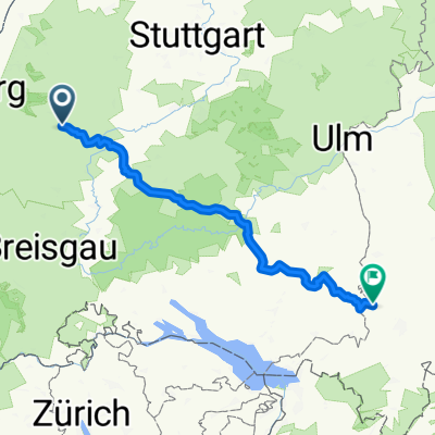
Schwarzwald Panorama-Radweg Tag 2
A cycling route starting in Freudenstadt, Baden-Wurttemberg, Germany.
Overview
About this route
Beautiful multi-day tour through the Black Forest, also very suitable for less trained cyclists.
- -:--
- Duration
- 59.1 km
- Distance
- 528 m
- Ascent
- 495 m
- Descent
- ---
- Avg. speed
- ---
- Max. altitude

Route quality
Waytypes & surfaces along the route
Waytypes
Quiet road
27.2 km
(46 %)
Track
16.6 km
(28 %)
Surfaces
Paved
39.6 km
(67 %)
Unpaved
10.1 km
(17 %)
Asphalt
38.4 km
(65 %)
Gravel
8.9 km
(15 %)
Route highlights
Points of interest along the route

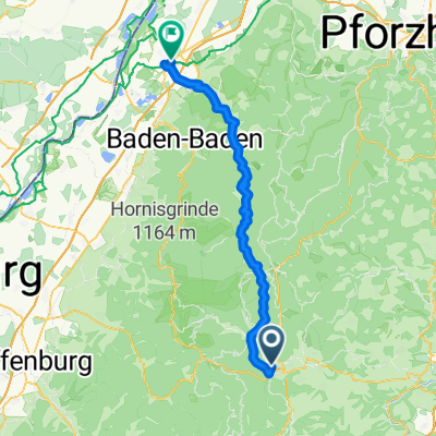
Point of interest after 6.5 km
Blick vom Vogteiturm

Point of interest after 37 km
grandioser Ausblick
Continue with Bikemap
Use, edit, or download this cycling route
You would like to ride Schwarzwald Panorama-Radweg Tag 2 or customize it for your own trip? Here is what you can do with this Bikemap route:
Free features
- Save this route as favorite or in collections
- Copy & plan your own version of this route
- Sync your route with Garmin or Wahoo
Premium features
Free trial for 3 days, or one-time payment. More about Bikemap Premium.
- Navigate this route on iOS & Android
- Export a GPX / KML file of this route
- Create your custom printout (try it for free)
- Download this route for offline navigation
Discover more Premium features.
Get Bikemap PremiumFrom our community
Other popular routes starting in Freudenstadt
 Kurze Ausfahrt durch Freudenstadt
- Distance
- 0 km
- Ascent
- 0 m
- Descent
- 0 m
- Location
- Freudenstadt, Baden-Wurttemberg, Germany
 Zwei-Täler-Tour
- Distance
- 51.5 km
- Ascent
- 942 m
- Descent
- 942 m
- Location
- Freudenstadt, Baden-Wurttemberg, Germany
 Baiersbronn Tonbach Huzenbachseeblick Ruhestein Schliffkopf FDS
- Distance
- 64.6 km
- Ascent
- 833 m
- Descent
- 833 m
- Location
- Freudenstadt, Baden-Wurttemberg, Germany
 Von Freudenstadt bis Elzach
- Distance
- 73.1 km
- Ascent
- 1,891 m
- Descent
- 2,225 m
- Location
- Freudenstadt, Baden-Wurttemberg, Germany
 Route nach Altusried
- Distance
- 204.2 km
- Ascent
- 2,519 m
- Descent
- 2,417 m
- Location
- Freudenstadt, Baden-Wurttemberg, Germany
 Tour de Murg CLONED FROM ROUTE 289506
- Distance
- 67.8 km
- Ascent
- 134 m
- Descent
- 761 m
- Location
- Freudenstadt, Baden-Wurttemberg, Germany
 E1-Freudenst-Donaueschingen
- Distance
- 84.8 km
- Ascent
- 1,014 m
- Descent
- 1,070 m
- Location
- Freudenstadt, Baden-Wurttemberg, Germany
 Schwarzwald Panorama-Radweg Tag 2
- Distance
- 59.1 km
- Ascent
- 528 m
- Descent
- 495 m
- Location
- Freudenstadt, Baden-Wurttemberg, Germany
Open it in the app