

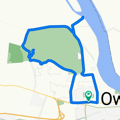
118 W Veterans Blvd, Owensboro to 10805 Red Hill Maxwell Rd, Utica
A cycling route starting in Owensboro, Kentucky, United States.
Overview
About this route
- 1 h 30 min
- Duration
- 34.2 km
- Distance
- 158 m
- Ascent
- 137 m
- Descent
- 22.7 km/h
- Avg. speed
- 158 m
- Max. altitude
Route quality
Waytypes & surfaces along the route
Waytypes
Busy road
27.1 km
(79 %)
Quiet road
3 km
(9 %)
Continue with Bikemap
Use, edit, or download this cycling route
You would like to ride 118 W Veterans Blvd, Owensboro to 10805 Red Hill Maxwell Rd, Utica or customize it for your own trip? Here is what you can do with this Bikemap route:
Free features
- Save this route as favorite or in collections
- Copy & plan your own version of this route
- Sync your route with Garmin or Wahoo
Premium features
Free trial for 3 days, or one-time payment. More about Bikemap Premium.
- Navigate this route on iOS & Android
- Export a GPX / KML file of this route
- Create your custom printout (try it for free)
- Download this route for offline navigation
Discover more Premium features.
Get Bikemap PremiumFrom our community
Other popular routes starting in Owensboro
 Greenbelt
- Distance
- 10.6 km
- Ascent
- 42 m
- Descent
- 38 m
- Location
- Owensboro, Kentucky, United States
 6 mile ride
- Distance
- 9.7 km
- Ascent
- 15 m
- Descent
- 15 m
- Location
- Owensboro, Kentucky, United States
 Overstreet Road 166, Owensboro to Overstreet Road 166, Owensboro
- Distance
- 4.5 km
- Ascent
- 78 m
- Descent
- 77 m
- Location
- Owensboro, Kentucky, United States
 040.Owensboro-Shawneetown_118
- Distance
- 111.7 km
- Ascent
- 224 m
- Descent
- 218 m
- Location
- Owensboro, Kentucky, United States
 around Ben Hall State Park
- Distance
- 18 km
- Ascent
- 58 m
- Descent
- 57 m
- Location
- Owensboro, Kentucky, United States
 8 mile Underground and Ramblin River
- Distance
- 13.2 km
- Ascent
- 30 m
- Descent
- 28 m
- Location
- Owensboro, Kentucky, United States
 going
going- Distance
- 3.9 km
- Ascent
- 16 m
- Descent
- 18 m
- Location
- Owensboro, Kentucky, United States
 118 W Veterans Blvd, Owensboro to 10805 Red Hill Maxwell Rd, Utica
- Distance
- 34.2 km
- Ascent
- 158 m
- Descent
- 137 m
- Location
- Owensboro, Kentucky, United States
Open it in the app