

45.794° N 4.921° W nach 45.977° N 5.305° W
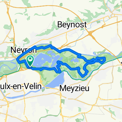
A cycling route starting in Vaulx-en-Velin, Auvergne-Rhône-Alpes, France.
Overview
About this route
- 2 h 14 min
- Duration
- 49.8 km
- Distance
- 405 m
- Ascent
- 331 m
- Descent
- 22.2 km/h
- Avg. speed
- 268 m
- Max. altitude

Route quality
Waytypes & surfaces along the route
Waytypes
Road
16.9 km
(34 %)
Quiet road
9.1 km
(18 %)
Surfaces
Paved
27.6 km
(55 %)
Unpaved
6.7 km
(13 %)
Asphalt
27.5 km
(55 %)
Gravel
4.4 km
(9 %)
Continue with Bikemap
Use, edit, or download this cycling route
You would like to ride 45.794° N 4.921° W nach 45.977° N 5.305° W or customize it for your own trip? Here is what you can do with this Bikemap route:
Free features
- Save this route as favorite or in collections
- Copy & plan your own version of this route
- Sync your route with Garmin or Wahoo
Premium features
Free trial for 3 days, or one-time payment. More about Bikemap Premium.
- Navigate this route on iOS & Android
- Export a GPX / KML file of this route
- Create your custom printout (try it for free)
- Download this route for offline navigation
Discover more Premium features.
Get Bikemap PremiumFrom our community
Other popular routes starting in Vaulx-en-Velin
 Route from Chemin de la Bletta, Vaulx-en-Velin
- Distance
- 28.5 km
- Ascent
- 40 m
- Descent
- 40 m
- Location
- Vaulx-en-Velin, Auvergne-Rhône-Alpes, France
 Petra
Petra- Distance
- 17.6 km
- Ascent
- 220 m
- Descent
- 119 m
- Location
- Vaulx-en-Velin, Auvergne-Rhône-Alpes, France
 De Boulevard des Droits de l'Homme 9, Vaulx-en-Velin à Chemin de Halage, Décines-Charpieu
- Distance
- 3.8 km
- Ascent
- 185 m
- Descent
- 242 m
- Location
- Vaulx-en-Velin, Auvergne-Rhône-Alpes, France
 Autour du parc
- Distance
- 41.8 km
- Ascent
- 200 m
- Descent
- 200 m
- Location
- Vaulx-en-Velin, Auvergne-Rhône-Alpes, France
 Allée de la Plage, Vaulx-en-Velin à 5 Cours Bayard, Lyon
- Distance
- 20.8 km
- Ascent
- 78 m
- Descent
- 81 m
- Location
- Vaulx-en-Velin, Auvergne-Rhône-Alpes, France
 De Chemin de la Bletta, Vaulx-en-Velin à Chemin de la Bletta, Vaulx-en-Velin
- Distance
- 15.6 km
- Ascent
- 77 m
- Descent
- 76 m
- Location
- Vaulx-en-Velin, Auvergne-Rhône-Alpes, France
 De Grand Parc le Morlet, Vaulx-en-Velin à Montée de la Boucle 3, Caluire-et-Cuire
- Distance
- 12.5 km
- Ascent
- 116 m
- Descent
- 109 m
- Location
- Vaulx-en-Velin, Auvergne-Rhône-Alpes, France
 4. Etappe Oberdiessbach - Le Lavandou (Sault Brénaz - Vienne)
- Distance
- 49.4 km
- Ascent
- 669 m
- Descent
- 684 m
- Location
- Vaulx-en-Velin, Auvergne-Rhône-Alpes, France
Open it in the app