

Riesling
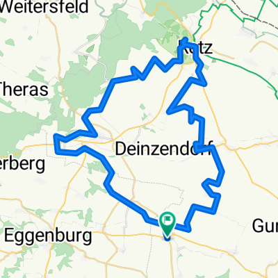
A cycling route starting in Zellerndorf, Lower Austria, Austria.
Overview
About this route
- -:--
- Duration
- 52.3 km
- Distance
- 379 m
- Ascent
- 383 m
- Descent
- ---
- Avg. speed
- 427 m
- Max. altitude

Route quality
Waytypes & surfaces along the route
Waytypes
Quiet road
22.5 km
(43 %)
Track
20.9 km
(40 %)
Surfaces
Paved
36.6 km
(70 %)
Unpaved
3.7 km
(7 %)
Asphalt
34 km
(65 %)
Gravel
3.7 km
(7 %)
Route highlights
Points of interest along the route
Point of interest after 44.7 km
Continue with Bikemap
Use, edit, or download this cycling route
You would like to ride Riesling or customize it for your own trip? Here is what you can do with this Bikemap route:
Free features
- Save this route as favorite or in collections
- Copy & plan your own version of this route
- Sync your route with Garmin or Wahoo
Premium features
Free trial for 3 days, or one-time payment. More about Bikemap Premium.
- Navigate this route on iOS & Android
- Export a GPX / KML file of this route
- Create your custom printout (try it for free)
- Download this route for offline navigation
Discover more Premium features.
Get Bikemap PremiumFrom our community
Other popular routes starting in Zellerndorf
 Zellerndorf - Krems 2021
- Distance
- 67.4 km
- Ascent
- 626 m
- Descent
- 649 m
- Location
- Zellerndorf, Lower Austria, Austria
 burgunder-chardonnayweg
- Distance
- 66.7 km
- Ascent
- 536 m
- Descent
- 535 m
- Location
- Zellerndorf, Lower Austria, Austria
 Platt- Röschitz, Weberkeller
- Distance
- 9.8 km
- Ascent
- 100 m
- Descent
- 62 m
- Location
- Zellerndorf, Lower Austria, Austria
 Roseldorf 63 nach Roseldorf 63
- Distance
- 62.6 km
- Ascent
- 993 m
- Descent
- 984 m
- Location
- Zellerndorf, Lower Austria, Austria
 2020_KTM_04_Zellerndorf_Slavonice
- Distance
- 82.1 km
- Ascent
- 745 m
- Descent
- 451 m
- Location
- Zellerndorf, Lower Austria, Austria
 Zellerndorf - Raabs an der Thaya
- Distance
- 55.3 km
- Ascent
- 589 m
- Descent
- 399 m
- Location
- Zellerndorf, Lower Austria, Austria
 Pillersdorf-Zellerndorf-Pfaffemdorf-Ragelsdorf-Retu-Pillersdorf
- Distance
- 34.1 km
- Ascent
- 382 m
- Descent
- 320 m
- Location
- Zellerndorf, Lower Austria, Austria
 burgunder-chardonnayweg
- Distance
- 66.7 km
- Ascent
- 819 m
- Descent
- 816 m
- Location
- Zellerndorf, Lower Austria, Austria
Open it in the app