- 57.4 km
- 1,071 m
- 1,071 m
- Bad Leonfelden, Upper Austria, Austria
Bad Leonfelden
A cycling route starting in Bad Leonfelden, Upper Austria, Austria.
Overview
About this route
Easy route through the hilly Mühlviertel
Ride from the center via Piberstein to Guglwald, up and down amidst beautiful scenery. The route from Guglwald down to the center - on the main road - is not very thrilling. There is quite a bit of traffic at times and long uphill stretches.
All in all, a very nice family ride for the weekend.
Elevation gain of about 400m
- -:--
- Duration
- 34.2 km
- Distance
- 515 m
- Ascent
- 515 m
- Descent
- ---
- Avg. speed
- ---
- Max. altitude
created this 14 years ago
Route quality
Waytypes & surfaces along the route
Waytypes
Road
16.1 km
(47 %)
Quiet road
9.2 km
(27 %)
Surfaces
Paved
17.1 km
(50 %)
Asphalt
17.1 km
(50 %)
Undefined
17.1 km
(50 %)
Continue with Bikemap
Use, edit, or download this cycling route
You would like to ride Bad Leonfelden or customize it for your own trip? Here is what you can do with this Bikemap route:
Free features
- Save this route as favorite or in collections
- Copy & plan your own version of this route
- Sync your route with Garmin or Wahoo
Premium features
Free trial for 3 days, or one-time payment. More about Bikemap Premium.
- Navigate this route on iOS & Android
- Export a GPX / KML file of this route
- Create your custom printout (try it for free)
- Download this route for offline navigation
Discover more Premium features.
Get Bikemap PremiumFrom our community
Other popular routes starting in Bad Leonfelden
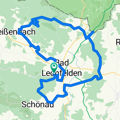
- RCO 2025 Bad Leonfelden Runde Lipno-Stausee
- von Bad Leonfelden nach Freistadt
- 28.7 km
- 418 m
- 564 m
- Bad Leonfelden, Upper Austria, Austria
- Schwedenschanze+Sternsteinrunde
- 39.1 km
- 485 m
- 633 m
- Bad Leonfelden, Upper Austria, Austria
- bl - schenkenfelden -hirschbach - reichenthal - bl
- 41.5 km
- 736 m
- 735 m
- Bad Leonfelden, Upper Austria, Austria
- Großtraberg CZ Dürnau, Walz
- 38.1 km
- 734 m
- 801 m
- Bad Leonfelden, Upper Austria, Austria
- Rading nach Weignersdorf
- 72.3 km
- 1,226 m
- 1,340 m
- Bad Leonfelden, Upper Austria, Austria
- Traberg - Sternsteinwarte - Traberg
- 29.8 km
- 879 m
- 921 m
- Bad Leonfelden, Upper Austria, Austria
- Großtraberg nach Lebzelterstraße
- 47.1 km
- 746 m
- 917 m
- Bad Leonfelden, Upper Austria, Austria
Open it in the app


