

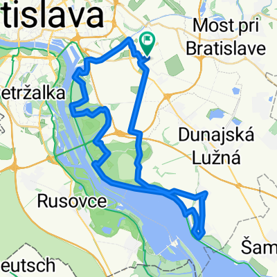
Bratislava Horská cyklistika 2.5.2022
A cycling route starting in Dunajská Lužná, Bratislava Region, Slovakia.
Overview
About this route
null
- -:--
- Duration
- 44.7 km
- Distance
- 100 m
- Ascent
- 100 m
- Descent
- ---
- Avg. speed
- 138 m
- Max. altitude

Continue with Bikemap
Use, edit, or download this cycling route
You would like to ride Bratislava Horská cyklistika 2.5.2022 or customize it for your own trip? Here is what you can do with this Bikemap route:
Free features
- Save this route as favorite or in collections
- Copy & plan your own version of this route
- Sync your route with Garmin or Wahoo
Premium features
Free trial for 3 days, or one-time payment. More about Bikemap Premium.
- Navigate this route on iOS & Android
- Export a GPX / KML file of this route
- Create your custom printout (try it for free)
- Download this route for offline navigation
Discover more Premium features.
Get Bikemap PremiumFrom our community
Other popular routes starting in Dunajská Lužná
 Nedeľný bajk Dunajska Luzna - Petrzalka
- Distance
- 17.5 km
- Ascent
- 29 m
- Descent
- 23 m
- Location
- Dunajská Lužná, Bratislava Region, Slovakia
 Lengthy bike tour through Rovinka
- Distance
- 36.5 km
- Ascent
- 18 m
- Descent
- 19 m
- Location
- Dunajská Lužná, Bratislava Region, Slovakia
 Rusovce - Autokemping - Rusovce
- Distance
- 19.8 km
- Ascent
- 12 m
- Descent
- 12 m
- Location
- Dunajská Lužná, Bratislava Region, Slovakia
 Po Dunajských luhoch a hrádzi Dunaja
- Distance
- 42.1 km
- Ascent
- 28 m
- Descent
- 28 m
- Location
- Dunajská Lužná, Bratislava Region, Slovakia
 Untitled route
- Distance
- 390.1 km
- Ascent
- 3,945 m
- Descent
- 3,870 m
- Location
- Dunajská Lužná, Bratislava Region, Slovakia
 PodBisk - Rovinka - Dunajska Luzna - Hamuliakovo - po hradzi aj lesom popri Dunaji - PodBisk
- Distance
- 36.1 km
- Ascent
- 130 m
- Descent
- 131 m
- Location
- Dunajská Lužná, Bratislava Region, Slovakia
 Tour de Bałkany 2017 dzień 2
- Distance
- 167.9 km
- Ascent
- 523 m
- Descent
- 541 m
- Location
- Dunajská Lužná, Bratislava Region, Slovakia
 Nepretržitá jazda Zonc
- Distance
- 35.2 km
- Ascent
- 119 m
- Descent
- 120 m
- Location
- Dunajská Lužná, Bratislava Region, Slovakia
Open it in the app