

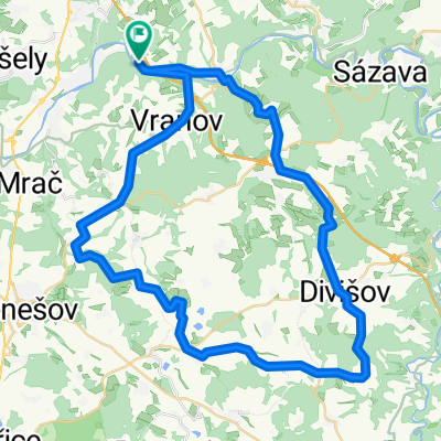
Posázaví 2022 - veteráni
A cycling route starting in Ondřejov, Central Bohemia, Czechia.
Overview
About this route
- -:--
- Duration
- 69.9 km
- Distance
- 1,270 m
- Ascent
- 1,074 m
- Descent
- ---
- Avg. speed
- 526 m
- Max. altitude
Route quality
Waytypes & surfaces along the route
Waytypes
Road
52.5 km
(75 %)
Quiet road
1.4 km
(2 %)
Undefined
16.1 km
(23 %)
Surfaces
Paved
16.1 km
(23 %)
Asphalt
16.1 km
(23 %)
Undefined
53.9 km
(77 %)
Continue with Bikemap
Use, edit, or download this cycling route
You would like to ride Posázaví 2022 - veteráni or customize it for your own trip? Here is what you can do with this Bikemap route:
Free features
- Save this route as favorite or in collections
- Copy & plan your own version of this route
- Sync your route with Garmin or Wahoo
Premium features
Free trial for 3 days, or one-time payment. More about Bikemap Premium.
- Navigate this route on iOS & Android
- Export a GPX / KML file of this route
- Create your custom printout (try it for free)
- Download this route for offline navigation
Discover more Premium features.
Get Bikemap PremiumFrom our community
Other popular routes starting in Ondřejov
 Třiatřicítka
- Distance
- 32.9 km
- Ascent
- 486 m
- Descent
- 486 m
- Location
- Ondřejov, Central Bohemia, Czechia
 0030: Senohraby - Pětihosty - Pyšely - Nespeky
- Distance
- 8.3 km
- Ascent
- 471 m
- Descent
- 203 m
- Location
- Ondřejov, Central Bohemia, Czechia
 Turkovice-Propast-Ondřejov
- Distance
- 39.1 km
- Ascent
- 466 m
- Descent
- 466 m
- Location
- Ondřejov, Central Bohemia, Czechia
 Okruh na Sázavě
- Distance
- 35.5 km
- Ascent
- 707 m
- Descent
- 719 m
- Location
- Ondřejov, Central Bohemia, Czechia
 Kolem Posázaví 2018
- Distance
- 94.6 km
- Ascent
- 1,253 m
- Descent
- 1,058 m
- Location
- Ondřejov, Central Bohemia, Czechia
 Divišov
- Distance
- 50.5 km
- Ascent
- 574 m
- Descent
- 574 m
- Location
- Ondřejov, Central Bohemia, Czechia
 Voderady
- Distance
- 19 km
- Ascent
- 340 m
- Descent
- 336 m
- Location
- Ondřejov, Central Bohemia, Czechia
 Cesta kocoura Mikeše
- Distance
- 27.6 km
- Ascent
- 504 m
- Descent
- 442 m
- Location
- Ondřejov, Central Bohemia, Czechia
Open it in the app