

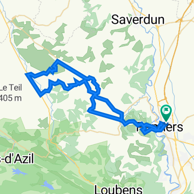
Pamiers - Puivert
A cycling route starting in Pamiers, Occitanie, France.
Overview
About this route
Camping de Fontclaire
Campsadourny, Rte de l'Escale, 11230 Puivert
- -:--
- Duration
- 56.6 km
- Distance
- 480 m
- Ascent
- 262 m
- Descent
- ---
- Avg. speed
- 493 m
- Max. altitude

Route quality
Waytypes & surfaces along the route
Waytypes
Path
17.5 km
(31 %)
Quiet road
14.7 km
(26 %)
Surfaces
Paved
5.1 km
(9 %)
Unpaved
5.7 km
(10 %)
Gravel
5.7 km
(10 %)
Asphalt
5.1 km
(9 %)
Undefined
45.8 km
(81 %)
Continue with Bikemap
Use, edit, or download this cycling route
You would like to ride Pamiers - Puivert or customize it for your own trip? Here is what you can do with this Bikemap route:
Free features
- Save this route as favorite or in collections
- Copy & plan your own version of this route
- Sync your route with Garmin or Wahoo
Premium features
Free trial for 3 days, or one-time payment. More about Bikemap Premium.
- Navigate this route on iOS & Android
- Export a GPX / KML file of this route
- Create your custom printout (try it for free)
- Download this route for offline navigation
Discover more Premium features.
Get Bikemap PremiumFrom our community
Other popular routes starting in Pamiers
 2016 Ride Day 56 - Pamiers to Nogaret
- Distance
- 77.1 km
- Ascent
- 468 m
- Descent
- 550 m
- Location
- Pamiers, Occitanie, France
 bike tour through Pamiers
- Distance
- 12.9 km
- Ascent
- 216 m
- Descent
- 216 m
- Location
- Pamiers, Occitanie, France
 Tour de France 2010 Stage15, Pamiers-Bagnères-de-Luchon
- Distance
- 152.9 km
- Ascent
- 2,269 m
- Descent
- 1,897 m
- Location
- Pamiers, Occitanie, France
 S_T7_ANT
- Distance
- 134.8 km
- Ascent
- 950 m
- Descent
- 642 m
- Location
- Pamiers, Occitanie, France
 France-Espagne-Maroc
- Distance
- 2,021.3 km
- Ascent
- 4,970 m
- Descent
- 5,237 m
- Location
- Pamiers, Occitanie, France
 XXVI° TAPPA
- Distance
- 99.6 km
- Ascent
- 1,006 m
- Descent
- 892 m
- Location
- Pamiers, Occitanie, France
 brevet des 150 kms aca pamiers gérard
- Distance
- 154.2 km
- Ascent
- 1,337 m
- Descent
- 1,337 m
- Location
- Pamiers, Occitanie, France
 ruta pamiers
- Distance
- 56.3 km
- Ascent
- 758 m
- Descent
- 759 m
- Location
- Pamiers, Occitanie, France
Open it in the app