

Wolkenburg Campingplatz
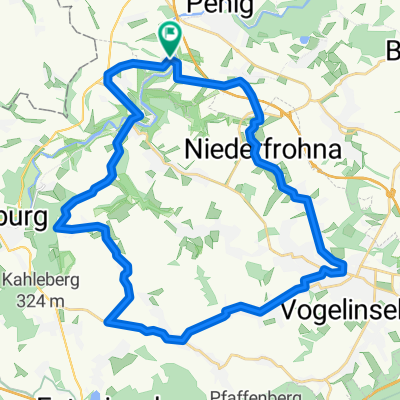
A cycling route starting in Penig, Saxony, Germany.
Overview
About this route
Easy simple route to warm up. Forest and gravel paths, and of course normal road. After rain, slippery curves shortly after Zinnberg in the forest.
- -:--
- Duration
- 13.9 km
- Distance
- 211 m
- Ascent
- 211 m
- Descent
- ---
- Avg. speed
- ---
- Max. altitude

Route quality
Waytypes & surfaces along the route
Waytypes
Quiet road
6.4 km
(46 %)
Track
3.9 km
(28 %)
Surfaces
Paved
8.1 km
(58 %)
Unpaved
4 km
(29 %)
Asphalt
7 km
(50 %)
Loose gravel
3.5 km
(25 %)
Continue with Bikemap
Use, edit, or download this cycling route
You would like to ride Wolkenburg Campingplatz or customize it for your own trip? Here is what you can do with this Bikemap route:
Free features
- Save this route as favorite or in collections
- Copy & plan your own version of this route
- Sync your route with Garmin or Wahoo
Premium features
Free trial for 3 days, or one-time payment. More about Bikemap Premium.
- Navigate this route on iOS & Android
- Export a GPX / KML file of this route
- Create your custom printout (try it for free)
- Download this route for offline navigation
Discover more Premium features.
Get Bikemap PremiumFrom our community
Other popular routes starting in Penig
 Waldenburg
- Distance
- 23.8 km
- Ascent
- 251 m
- Descent
- 248 m
- Location
- Penig, Saxony, Germany
 Penig - Burgstädt - Wechselburg und über Lunzenau zurück
- Distance
- 32.2 km
- Ascent
- 229 m
- Descent
- 316 m
- Location
- Penig, Saxony, Germany
 Wälder und Wiesen
- Distance
- 21.4 km
- Ascent
- 250 m
- Descent
- 250 m
- Location
- Penig, Saxony, Germany
 Berg- und Talfahrt rund um Kaufungen
- Distance
- 33 km
- Ascent
- 351 m
- Descent
- 301 m
- Location
- Penig, Saxony, Germany
 kleine Runde bei Penig
- Distance
- 28.1 km
- Ascent
- 365 m
- Descent
- 377 m
- Location
- Penig, Saxony, Germany
 Wolkenburg Campingplatz
- Distance
- 13.9 km
- Ascent
- 211 m
- Descent
- 211 m
- Location
- Penig, Saxony, Germany
 Waldenburg
- Distance
- 23.8 km
- Ascent
- 259 m
- Descent
- 256 m
- Location
- Penig, Saxony, Germany
 Weiße Spitze-Rochsburg-Brausetal
- Distance
- 29.9 km
- Ascent
- 314 m
- Descent
- 314 m
- Location
- Penig, Saxony, Germany
Open it in the app