

do Holi
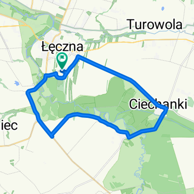
A cycling route starting in Łęczna, Lublin Voivodeship, Poland.
Overview
About this route
- -:--
- Duration
- 134.7 km
- Distance
- 118 m
- Ascent
- 119 m
- Descent
- ---
- Avg. speed
- ---
- Max. altitude
Route highlights
Points of interest along the route

Point of interest after 12.6 km
Cerkiew

Point of interest after 20.3 km
Rezerwat "Brzeziczno"

Point of interest after 47.5 km
Obóz powstańczy

Point of interest after 54.2 km
Kurhan "Szwedzka Mogiła"

Point of interest after 59.7 km
Cerkiew

Point of interest after 59.7 km
Kościół z 1797 roku

Point of interest after 75.9 km
Skansen

Point of interest after 97.1 km
Kościół parafialny z ołtarzem głównym z I poł. XVIIw.

Point of interest after 98.4 km
XIX w. wiatrak typu koźlak

Point of interest after 105.2 km
ODM PPN

Point of interest after 108.4 km
Pomnik przyrody dąb szypułkowy o obwodzie pnia 460 cm.
Continue with Bikemap
Use, edit, or download this cycling route
You would like to ride do Holi or customize it for your own trip? Here is what you can do with this Bikemap route:
Free features
- Save this route as favorite or in collections
- Copy & plan your own version of this route
- Split it into stages to create a multi-day tour
- Sync your route with Garmin or Wahoo
Premium features
Free trial for 3 days, or one-time payment. More about Bikemap Premium.
- Navigate this route on iOS & Android
- Export a GPX / KML file of this route
- Create your custom printout (try it for free)
- Download this route for offline navigation
Discover more Premium features.
Get Bikemap PremiumFrom our community
Other popular routes starting in Łęczna
 Pętelka Kaśki
- Distance
- 17.8 km
- Ascent
- 65 m
- Descent
- 65 m
- Location
- Łęczna, Lublin Voivodeship, Poland
 "urwane" tory
- Distance
- 30.9 km
- Ascent
- 149 m
- Descent
- 148 m
- Location
- Łęczna, Lublin Voivodeship, Poland
 I rajd rowerowy "Łęczna na rowery"
- Distance
- 36.8 km
- Ascent
- 60 m
- Descent
- 59 m
- Location
- Łęczna, Lublin Voivodeship, Poland
 do Holi
- Distance
- 134.7 km
- Ascent
- 118 m
- Descent
- 119 m
- Location
- Łęczna, Lublin Voivodeship, Poland
 Trasa na 19.08.2012
- Distance
- 57.9 km
- Ascent
- 31 m
- Descent
- 33 m
- Location
- Łęczna, Lublin Voivodeship, Poland
 Łęczna na rowery III - nie gazuj - jesień 2012
- Distance
- 37.2 km
- Ascent
- 63 m
- Descent
- 66 m
- Location
- Łęczna, Lublin Voivodeship, Poland
 Łęczna-Bogdanka-Piaseczno-Rogóźno-Łęczna
- Distance
- 34 km
- Ascent
- 41 m
- Descent
- 38 m
- Location
- Łęczna, Lublin Voivodeship, Poland
 T4 Łęczna - Zawieprzyce - Łęczna
- Distance
- 31.2 km
- Ascent
- 84 m
- Descent
- 88 m
- Location
- Łęczna, Lublin Voivodeship, Poland
Open it in the app