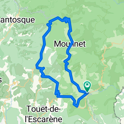
Campsite Sospel - Col du Turini
A cycling route starting in Sospel, Provence-Alpes-C么te d'Azur Region, France.
Overview
About this route
Summer 2010: From our campsite to the top of Col du Turini and back
- -:--
- Duration
- 40.9 km
- Distance
- 1,493 m
- Ascent
- 1,493 m
- Descent
- ---
- Avg. speed
- ---
- Max. altitude
Continue with Bikemap
Use, edit, or download this cycling route
You would like to ride Campsite Sospel - Col du Turini or customize it for your own trip? Here is what you can do with this Bikemap route:
Free features
- Save this route as favorite or in collections
- Copy & plan your own version of this route
- Sync your route with Garmin or Wahoo
Premium features
Free trial for 3 days, or one-time payment. More about Bikemap Premium.
- Navigate this route on iOS & Android
- Export a GPX / KML file of this route
- Create your custom printout (try it for free)
- Download this route for offline navigation
Discover more Premium features.
Get Bikemap PremiumFrom our community
Other popular routes starting in Sospel
Sospel to Thonon- Distance
- 632.9 km
- Ascent
- 11,662 m
- Descent
- 11,737 m
- Location
- Sospel, Provence-Alpes-C么te d'Azur Region, France
Southern French Alps 2004 stage 2- Distance
- 39.3 km
- Ascent
- 1,382 m
- Descent
- 912 m
- Location
- Sospel, Provence-Alpes-C么te d'Azur Region, France
Prowansja 9 - Sospel - Menton- Distance
- 52.2 km
- Ascent
- 1,218 m
- Descent
- 1,222 m
- Location
- Sospel, Provence-Alpes-C么te d'Azur Region, France
Tour 20: Col de Turini- Distance
- 112.6 km
- Ascent
- 2,704 m
- Descent
- 2,697 m
- Location
- Sospel, Provence-Alpes-C么te d'Azur Region, France
06 E Sospel - Olliveta Pienne Haute plus eBramafan 35K- Distance
- 34.7 km
- Ascent
- 1,230 m
- Descent
- 1,230 m
- Location
- Sospel, Provence-Alpes-C么te d'Azur Region, France
turini 2016- Distance
- 95 km
- Ascent
- 2,487 m
- Descent
- 2,481 m
- Location
- Sospel, Provence-Alpes-C么te d'Azur Region, France
Campsite Sospel - Moulinet - Sospel - Col du Braus- Distance
- 48 km
- Ascent
- 1,149 m
- Descent
- 1,134 m
- Location
- Sospel, Provence-Alpes-C么te d'Azur Region, France
Route in Sospel- Distance
- 59.2 km
- Ascent
- 4,538 m
- Descent
- 4,537 m
- Location
- Sospel, Provence-Alpes-C么te d'Azur Region, France
Open it in the app


